Category: Destinations

  • Todra and Dades Gorges: Morocco’s Most Spectacular Canyon Adventures

    Todra and Dades Gorges: Morocco’s Most Spectacular Canyon Adventures

    Morocco is a country of dramatic landscapes, but nothing quite prepares you for the moment when the flat, sunbaked terrain of the southern pre-Sahara suddenly splits open to reveal towering canyon walls rising 300 meters on either side. The Todra and Dades Gorges, carved over millions of years by rivers flowing from the High Atlas Mountains toward the Sahara, are two of the most visually stunning natural formations in North Africa. They sit roughly 50 kilometers apart in the Draa-Tafilalet region and together offer an extraordinary combination of geological spectacle, outdoor adventure, cultural heritage, and scenic driving that rivals anything on the continent.

    These gorges are more than scenic stops on the route to the Sahara. They are destinations in their own right, offering world-class rock climbing, memorable hiking trails, traditional Berber villages clinging to canyon walls, and the legendary Road of a Thousand Kasbahs, one of the most photogenic drives in the world. Whether you are a serious outdoor adventurer or a traveler who simply appreciates extraordinary scenery, the Todra and Dades Gorges deserve a prominent place in your Morocco itinerary.

    This guide covers everything you need to plan your visit, from trail descriptions and climbing information to practical logistics and how to combine the gorges with a Sahara Desert tour.

    Understanding the Geography

    How the Gorges Were Formed

    Both the Todra and Dades Gorges were created by the erosive power of rivers cutting through the limestone and sandstone layers of the eastern High Atlas Mountains over millions of years. The Todra River and the Dades River flow south from the mountains toward the Sahara, carving progressively deeper channels through the rock as the land slowly uplifted. The result is a pair of narrow, steep-walled canyons that transition from gentle, palm-filled valleys at their mouths to dramatic vertical cliffs at their narrowest points.

    Where They Are

    Both gorges are located in the province of Tinghir, in the Draa-Tafilalet region of southeastern Morocco.

    • Todra Gorge lies approximately 15 kilometers north of the town of Tinghir, accessible via a paved road that follows the Todra River upstream into the mountains.
    • Dades Gorge begins about 5 kilometers north of the town of Boumalne Dades, roughly 50 kilometers west of Tinghir along the main N10 highway.

    The two gorges are connected by the N10 highway, which runs east-west along the southern edge of the High Atlas, making it easy to visit both in a single itinerary.

    Todra Gorge: The Main Attraction

    The Canyon

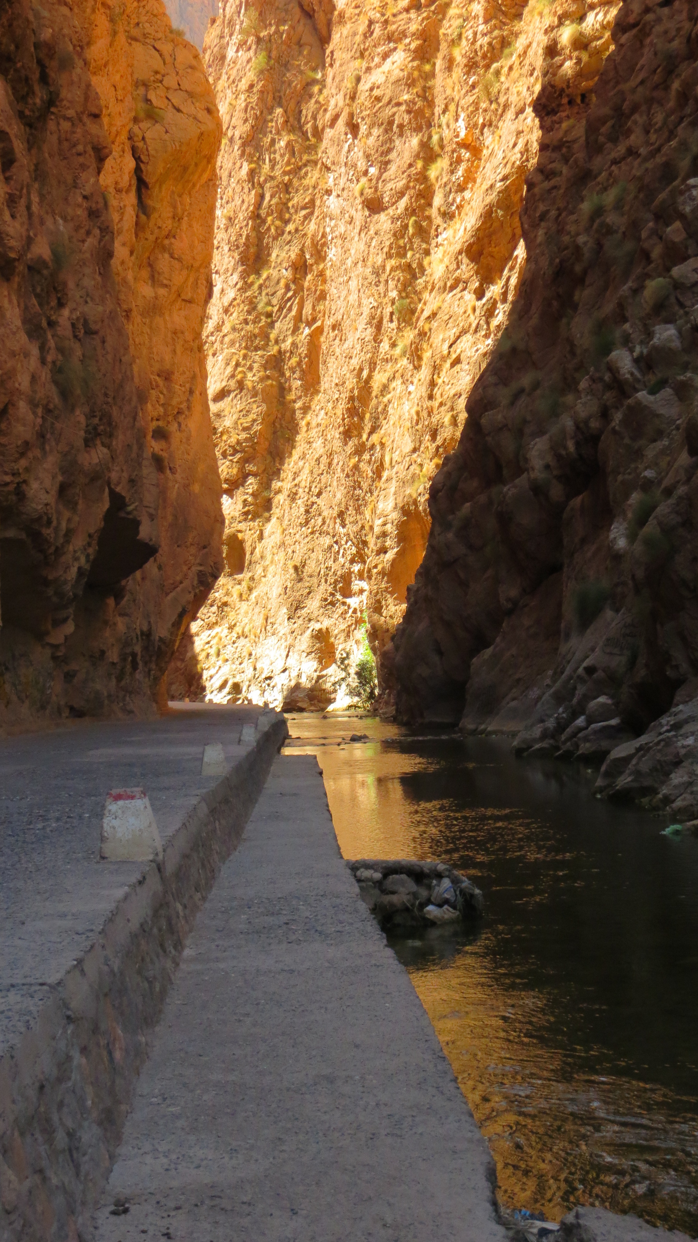
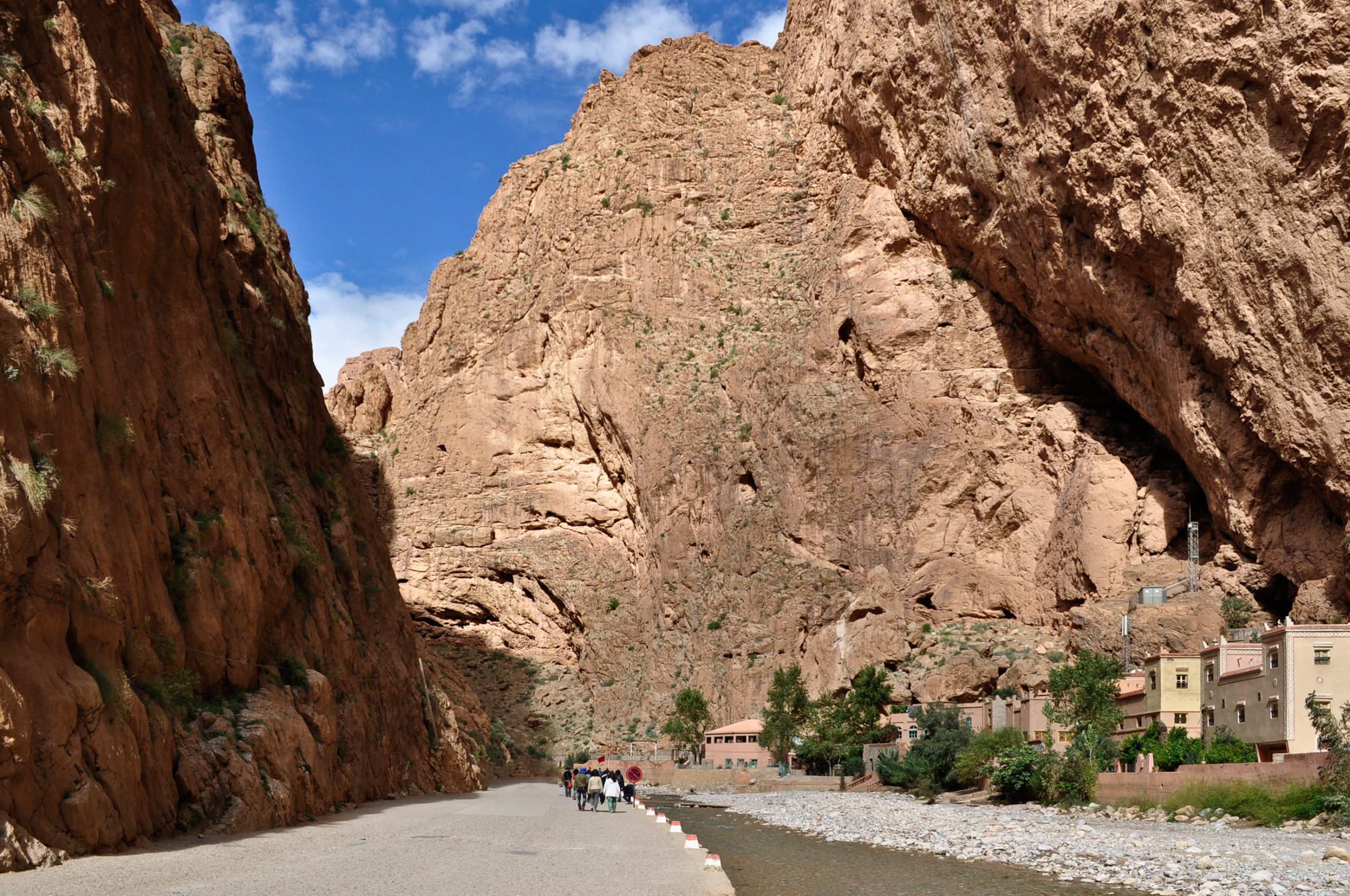
    Todra Gorge is the more famous and dramatic of the two, and for good reason. At its narrowest point, the canyon is only 10 meters wide, with smooth limestone walls rising vertically to approximately 300 meters on both sides. The effect is awe-inspiring: a narrow slot of sky visible far above, the sound of the river echoing off the walls, and a sudden drop in temperature as the shade of the canyon replaces the desert sun.

    The paved road from Tinghir follows the Todra River through a gradually narrowing valley lined with palm trees, Berber villages, and terraced gardens before reaching the dramatic narrows. The drive itself is beautiful, with red and orange rock formations, traditional kasbahs, and the contrast of green palms against the arid landscape.

    Hiking in Todra Gorge

    Todra Gorge offers several hiking options ranging from easy walks to challenging multi-day treks.

    Easy: The Canyon Walk (1 to 2 hours)

    The most popular and accessible option is simply walking through the narrowest section of the gorge. The flat, rocky path along the river bed runs for about 600 meters through the most dramatic part of the canyon. This requires no special equipment or fitness and is suitable for all ages. The path continues beyond the narrows into the upper valley, where you can extend your walk through Berber villages and agricultural terraces.

    Moderate: The Gorge Loop Trail (3 to 5 hours)

    A circuit trail climbs from the canyon floor up to the rim of the gorge, follows the plateau with panoramic views down into the canyon, and descends back to the starting point. This trail involves some scrambling and moderate elevation gain (approximately 400 meters) and requires sturdy footwear and a reasonable level of fitness. The views from the rim are spectacular and far less crowded than the canyon floor.

    Challenging: Upper Todra Valley Trek (Full Day or Multi-Day)

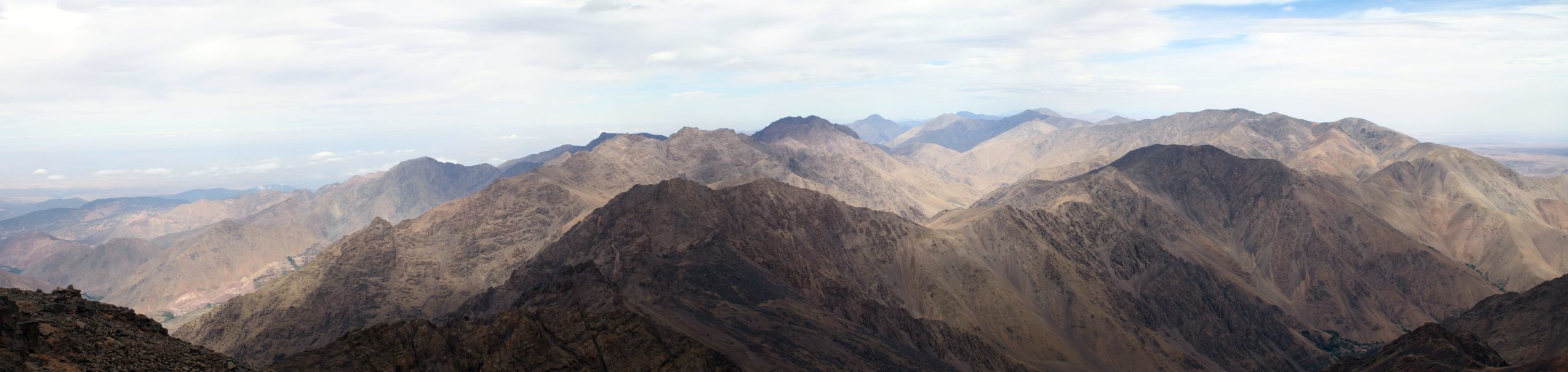
    For serious hikers, the Todra River valley extends deep into the High Atlas Mountains beyond the gorge. Multi-day treks can be arranged from Tinghir through traditional Berber villages like Tamtatouchte, Ait Hani, and beyond, eventually crossing mountain passes above 2,500 meters. These treks require a local guide, proper equipment, and advance planning.

    Moderate to Challenging: Todra to Dades Traverse (2 to 3 Days)

    An ambitious and rewarding option for experienced hikers is the cross-country trek connecting the upper Todra Valley to the upper Dades Valley, crossing a series of mountain ridges and passes. This remote route passes through villages rarely visited by tourists and offers a genuine immersion in Berber mountain culture. A knowledgeable local guide is essential.

    Rock Climbing in Todra Gorge

    Todra Gorge has become one of the premier rock climbing destinations in Africa and attracts climbers from around the world, particularly during the cooler months.

    The Rock

    The climbing walls are high-quality limestone, typically featuring vertical to slightly overhanging faces with a variety of holds including pockets, crimps, edges, and occasional tufas. The rock is generally solid, though some routes pass through sections that require care.

    Routes and Grades

    There are over 150 documented climbing routes in the gorge area, ranging from beginner-friendly 4a to demanding 8a+ (French grading system). The majority of routes are single-pitch sport climbs in the 5 to 7 range, well-bolted and accessible. Multi-pitch routes up to 300 meters are also available for experienced climbers.

    The most famous climbing area is the “Pilier du Couchant” (Sunset Pillar), which offers multi-pitch routes on the west-facing wall of the main gorge. Other popular sectors include “Mansour,” “Petite Gorge,” and the walls above the river in the main canyon.

    Climbing Season

    The best climbing conditions are from October through May, when temperatures in the gorge are comfortable (15 to 25 degrees Celsius during the day). Summer climbing is possible in the early morning and late afternoon, as the gorge walls provide shade for much of the day, but midday temperatures can be prohibitively hot.

    Practicalities

    Local climbing guides and equipment rental are available in Tinghir. Several guesthouses near the gorge cater specifically to climbers and can arrange guiding, equipment, and route information. If you plan to climb, bring your own harness, shoes, and chalk; while rentals exist, quality and fit can be variable.

    Dades Gorge: The Scenic Alternative

    The Canyon

    Dades Gorge is less vertically dramatic than Todra but arguably more scenic overall, with a wider valley, more varied rock formations, and a paved road that winds through the gorge offering a spectacular drive. The canyon walls display vivid layers of red, orange, pink, and cream-colored sedimentary rock, twisted and folded by geological forces into formations that look almost sculptural.

    The most photographed section of the Dades Gorge is the series of tight switchback turns on the road as it climbs from the valley floor up the canyon wall. These hairpin curves, sometimes called the “Monkey Fingers” road (after the unusual rock formations nearby), are a visual spectacle both from below and from above.

    The Monkey Fingers

    The “Monkey Fingers” (or “Pattes de Singe”) are a set of bizarre rock formations near the entrance to the gorge. Tall, thin columns of conglomerate rock have been eroded into shapes that resemble elongated fingers reaching skyward. They are best viewed from the opposite side of the valley in the morning light and are a popular photography stop.

    Hiking in Dades Gorge

    Easy: Valley Floor Walk (1 to 3 hours)

    A gentle walk along the Dades River through the lower gorge, passing through Berber villages, walnut groves, and almond orchards. The path is flat and easy, with the dramatic canyon walls providing a stunning backdrop. Spring (late March through April) is particularly beautiful when the almond and fruit trees are in bloom.

    Moderate: Canyon Rim Trail (3 to 5 hours)

    A trail from the village of Ait Oudinar climbs to the rim of the gorge, offering dramatic views down into the valley and across to the surrounding mountains. The trail is well-established but involves steady climbing and some rocky sections.

    Moderate: Nomad Canyon (Half Day)

    A side canyon accessible from the main gorge road, Nomad Canyon is a narrow slot canyon with a short, atmospheric hike through water-carved rock passages. It is less visited than the main gorge and offers a sense of discovery.

    Challenging: High Atlas Passes (Multi-Day)

    Like Todra, the upper Dades Valley provides access to the High Atlas for multi-day trekking. The terrain is wilder and less frequented than the Todra side, offering genuine remote mountain trekking through traditional Berber territories.

    The Road of a Thousand Kasbahs

    The N10 highway that connects the Dades and Todra Gorges is part of the famous “Route des Mille Kasbahs” (Road of a Thousand Kasbahs), one of Morocco’s most celebrated scenic roads. This route runs roughly east-west along the southern edge of the High Atlas, through a landscape dotted with crumbling and restored kasbahs, fortified villages (ksour), palm oasis valleys, and dramatic mountain scenery.

    What is a Kasbah?

    A kasbah is a traditional Moroccan fortified residence, typically built of pisé (rammed earth and straw) with distinctive crenellated towers and geometric decorative patterns. Kasbahs were the homes of local chieftains and wealthy families, serving as both residences and defensive strongholds. The southern Morocco landscape is densely populated with kasbahs, many in various states of preservation, from meticulously restored to poetically crumbling.

    Key Kasbahs Along the Route

    • Kasbah of Amridil (Skoura): One of the best-preserved kasbahs in Morocco, still partially inhabited by the original family, and featured on the old 50-dirham banknote.
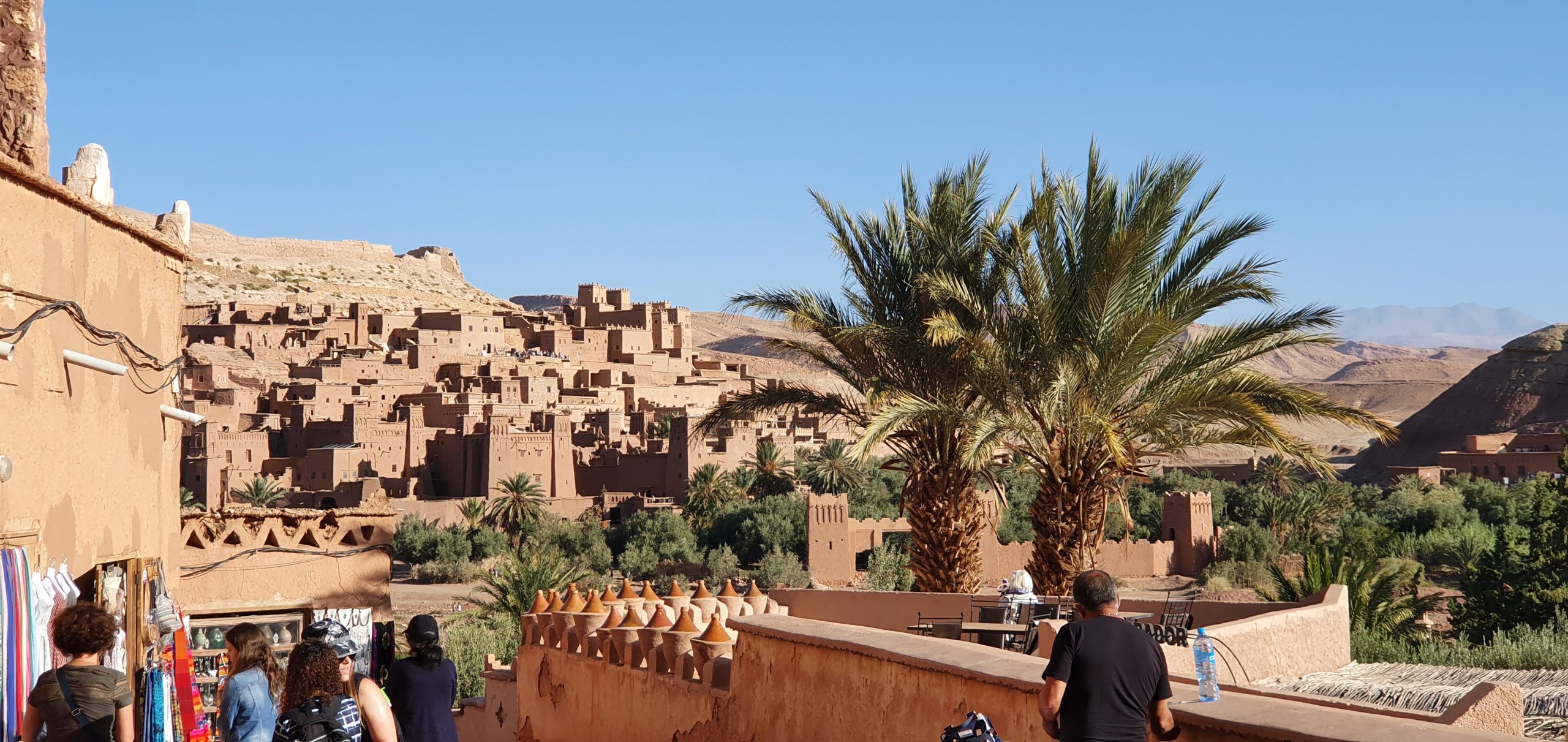
    • Kasbah Ait Ben Haddou (further west): A UNESCO World Heritage Site and the most famous kasbah complex in Morocco, used as a filming location for numerous films and television productions.
    • Kasbahs of Kelaat M’Gouna: The “Rose Valley” area, famous for its annual rose festival in May and the kasbahs scattered through the surrounding valley.
    • Kasbahs of the Dades and Todra Valleys: Both gorge valleys are lined with kasbahs and ksour that blend into the red and orange rock, sometimes almost invisible until you are directly beside them.

    Driving the Road of a Thousand Kasbahs between the two gorges is an experience that combines natural scenery with architectural heritage and provides context for the human history of this dramatic landscape.

    Best Time to Visit the Gorges

    Spring (March to May): The Ideal Season

    Spring is widely considered the best time to visit both gorges. Daytime temperatures are comfortable at 20 to 28 degrees Celsius, the rivers are flowing with snowmelt from the High Atlas, and the valley floors are green with new growth. Almond and fruit trees bloom in late March and April, adding splashes of white and pink to the red rock landscape. Hiking and climbing conditions are excellent.

    Autumn (September to November): The Second Best

    Autumn offers similar temperatures to spring with slightly drier conditions. The light is golden and warm, excellent for photography. The rivers are lower than in spring but still flowing. Climbing season is in full swing from October onward.

    Winter (December to February): Cool but Clear

    Winter brings cool to cold temperatures (5 to 18 degrees Celsius during the day, below freezing at night at higher elevations). The gorges are quiet and uncrowded, and the clear winter light makes the rock colors particularly vivid. Snow may be visible on the High Atlas peaks above the gorges, adding drama to photographs. Climbing is possible on sunny walls.

    Summer (June to August): Hot but Manageable

    Summer temperatures can reach 40 degrees Celsius in the lower valleys, but the gorge interiors are significantly cooler due to shade and the river. Morning and late afternoon visits are most comfortable. This is the quietest tourist season, and accommodation prices are lowest.

    Practical Information

    Getting There

    From Marrakech: The drive from Marrakech to the gorges takes approximately 6 to 7 hours via the Tizi n’Tichka pass and Ouarzazate. This is a spectacular drive in itself, crossing the High Atlas at 2,260 meters and passing through the Ait Benhaddou UNESCO site.

    From Fez: The route from Fez passes through the Middle Atlas, Midelt, and the Ziz Valley before reaching the gorge region, a journey of 7 to 8 hours. Many travelers combine this with the onward journey to the Sahara.

    From Merzouga/Erg Chebbi: The gorges are 2 to 3 hours west of Merzouga, making them a natural stop on the way to or from the Sahara Desert.

    Accommodation

    Both gorges have a range of accommodation options:

    • Budget: Simple guesthouses and auberges within the gorge valleys, often family-run, offering basic but clean rooms and home-cooked Berber meals. Expect to pay 200 to 400 MAD per person including dinner and breakfast.
    • Mid-Range: Comfortable hotels and riads in Tinghir, Boumalne Dades, and within the gorge valleys, with private rooms, hot showers, and terraces overlooking the canyon.
    • Upscale: A few boutique lodges offer more refined accommodation with pools, spas, and panoramic terrace restaurants.

    Guides

    For canyon floor walks and short hikes, a guide is not strictly necessary, as the main trails are well-trodden and straightforward. However, for rim trails, multi-day treks, slot canyon exploration, and rock climbing, hiring a local guide significantly enhances both safety and the quality of the experience. Guides can be arranged through your accommodation, through your tour operator, or at the gorge entrance.

    Safety Considerations

    • Flash floods: Both gorges are subject to flash flooding, particularly in autumn and spring when rain falls in the mountains upstream. The weather in the canyon may be sunny while a storm upstream sends a wall of water through the narrows. Never camp on the canyon floor, heed local warnings, and check weather forecasts for the mountain regions, not just the gorge location.
    • Sun exposure: Despite the shade in the narrowest sections, much of the hiking in and around the gorges is exposed. Bring sun protection, water, and a hat.
    • Loose rock: Canyon walls shed rock. Avoid lingering beneath overhanging sections, and wear a helmet if climbing.
    • River crossings: In spring, the river in Todra Gorge may require wading. Bring waterproof footwear or be prepared for wet feet.

    Combining the Gorges with a Sahara Desert Tour

    The Todra and Dades Gorges sit directly on the most popular route between Marrakech (or Fez) and the Sahara Desert, making them a natural and rewarding addition to any desert itinerary. Rather than treating them as a brief roadside stop, we recommend dedicating at least one full day, ideally two, to explore the gorges properly.

    A Typical Combined Itinerary

    A well-paced itinerary combining the gorges and the Sahara might look like this:

    Day 1: Depart Marrakech, cross the High Atlas via Tizi n’Tichka, visit Ait Benhaddou, overnight in the Dades Valley or gorge.

    Day 2: Explore Dades Gorge in the morning (drive the switchbacks, visit the Monkey Fingers, short hike). Drive to Todra Gorge in the afternoon, walk through the narrows, overnight near Tinghir or in the gorge.

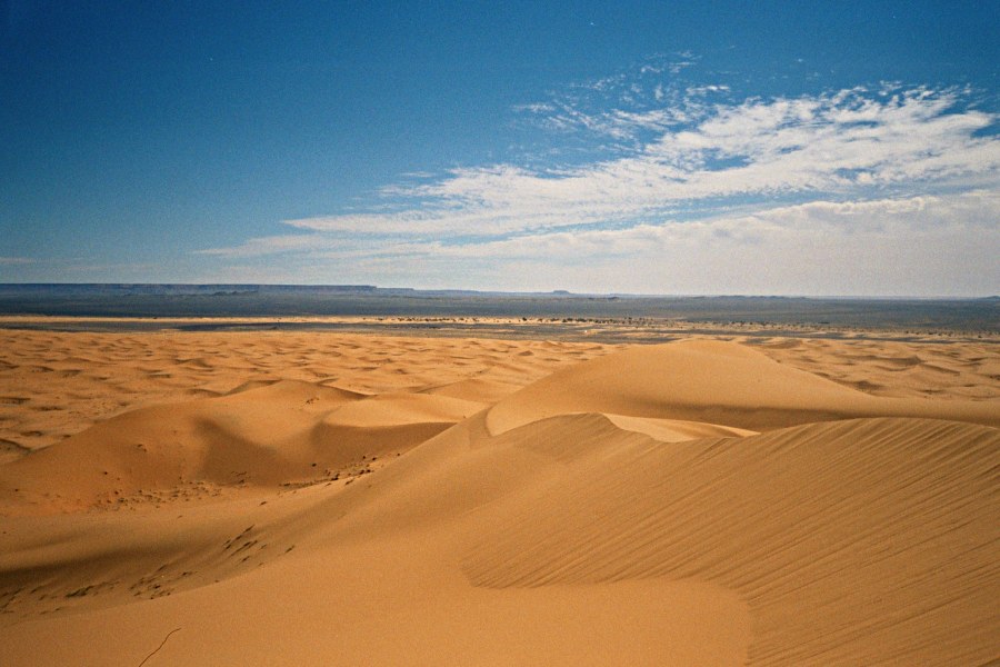
    Day 3: Morning in the Todra area (longer hike or free time), then drive east to Merzouga. Afternoon camel trek into the Erg Chebbi dunes, overnight in desert camp.

    Day 4: Sunrise in the dunes, return to Merzouga, then onward to your next destination.

    This pacing allows you to appreciate the gorges rather than merely driving through them and creates a satisfying narrative journey from mountains through canyons to desert.

    Duna Daurada Tours Through the Gorges

    Many of our desert tours include stops at the Todra and Dades Gorges as part of the route between Marrakech or Fez and the Sahara. Our local guides know the gorges intimately and can lead you to viewpoints, trails, and hidden corners that independent travelers often miss.

    If you want to spend extra time in the gorges for hiking, climbing, or photography, a custom tour allows you to adjust the itinerary to include as much gorge time as you want. Whether you are looking for a challenging multi-pitch climbing day or a gentle walk through a palm oasis, we can build it into your journey.

    Browse our available tours to see which itineraries include the gorges, or contact our team to discuss your interests and build the perfect route.

    Why the Gorges Matter

    The Todra and Dades Gorges are more than scenic attractions. They are windows into the geological history of Morocco, the cultural resilience of the Berber communities who have lived in these valleys for centuries, and the raw power of water and time to shape stone into art. Standing at the base of Todra’s 300-meter walls or winding through the switchbacks of the Dades road, you experience a sense of scale and natural grandeur that photographs, however stunning, cannot fully convey.

    For travelers on their way to the Sahara, the gorges provide a dramatic overture. They are the last act of verticality before the landscape opens into the horizontal infinity of the desert. The contrast between the enclosed, echoing canyons and the boundless silence of the dunes is one of the most powerful experiential transitions a Moroccan journey offers. Do not rush through them. Stop, walk, look up, and let the stone tell its story.

  • Ait Ben Haddou: Morocco’s UNESCO Kasbah and Hollywood’s Favorite Desert Set

    Ait Ben Haddou: Morocco’s UNESCO Kasbah and Hollywood’s Favorite Desert Set

    Rising from the arid riverbank of the Ounila Valley like a fortress from another age, Ait Ben Haddou is Morocco’s most dramatic architectural site and one of the most recognizable filming locations in the world. Its towers of red earthen clay, clustered homes climbing the hillside, and fortified granaries have appeared in dozens of Hollywood productions, from Lawrence of Arabia to Gladiator to Game of Thrones. Yet this is not a movie set. It is a real community with a thousand years of history, and it is one of the most rewarding stops on any journey between Marrakech and the Sahara Desert.

    This guide covers the history and significance of Ait Ben Haddou, the movies filmed here, practical visiting tips, photography advice, and how to include this extraordinary site in your desert tour itinerary.

    The History of Ait Ben Haddou

    Origins and Strategic Importance

    Ait Ben Haddou is a ksar, a fortified village composed of multiple kasbahs (family compounds) and individual dwellings enclosed within defensive walls. The exact founding date is debated, but the site is believed to have originated in the 11th century, during the Almoravid dynasty that controlled much of North Africa and southern Spain.

    The village’s location was strategic. Sitting at a natural crossroads between the Sahara Desert and the city of Marrakech, Ait Ben Haddou controlled a key section of the ancient trans-Saharan trade route. Camel caravans carrying gold, salt, ivory, and enslaved people passed through this valley on their journey between sub-Saharan Africa and the markets of the Mediterranean. The fortified architecture reflects this role: the thick walls, watchtowers, and elevated position were designed to protect the community and its trade goods from raiders and rivals.

    Architecture and Construction

    The buildings of Ait Ben Haddou are constructed from pise, a technique of rammed earth mixed with straw, lime, and water. The red-ochre color of the structures comes from the iron-rich local soil. Decorative elements include geometric patterns pressed into the wet clay, carved wooden lintels above doorways, and corner towers topped with crenellations.

    The ksar follows a hierarchical layout. The most important families lived in the largest kasbahs at the top of the hill, nearest to the communal granary (agadir) at the summit. The granary served as the community’s food reserve, storing grain, dates, nuts, and other provisions that would sustain the village during sieges or droughts. Its elevated, easily defended position reflects the crucial importance of food security in a region where resources were always scarce.

    Lower down the hillside, more modest homes housed ordinary families, and the outermost structures served as workshops, stables, and market spaces. The entire village was enclosed within a defensive wall with a single main gate, allowing the community to seal itself off from external threats.

    Decline and Preservation

    By the mid-20th century, Ait Ben Haddou’s strategic importance had faded. Modern roads bypassed the ancient trade routes, and many families moved across the river to a new village with better access to water, electricity, and transportation. The old ksar was gradually abandoned, and its earthen structures began to deteriorate.

    Recognition came in 1987, when UNESCO inscribed Ait Ben Haddou as a World Heritage Site, citing it as an outstanding example of a pre-Saharan earthen architecture settlement. The inscription brought international attention, conservation funding, and, inevitably, tourism. Restoration efforts have stabilized many of the structures, though the challenge of maintaining rammed earth buildings in an arid climate with occasional flash floods is ongoing.

    Today, a handful of families still live within the old ksar, maintaining a connection to the site that stretches back generations. Their presence adds an authenticity that purely preserved or reconstructed sites lack.

    Hollywood in the Desert: Movies Filmed at Ait Ben Haddou

    Ait Ben Haddou’s cinematic career began in the 1960s and has only accelerated since. The combination of spectacular architecture, dramatic natural setting, and proximity to Ouarzazate’s Atlas Studios (the largest film studio in Africa) has made it irresistible to filmmakers.

    The Major Productions

    Some of the most notable productions filmed at Ait Ben Haddou and the surrounding area include the following.

    Lawrence of Arabia (1962): David Lean’s epic used the Moroccan landscape extensively, and Ait Ben Haddou appeared in several scenes. The film’s sweeping desert visuals helped establish Morocco as a go-to location for Hollywood productions set in the Middle East and North Africa.

    Jesus of Nazareth (1977): Franco Zeffirelli’s television miniseries used Ait Ben Haddou as a stand-in for Jerusalem and other biblical locations. The aged, Middle Eastern appearance of the architecture required almost no modification.

    The Jewel of the Nile (1985): The adventure sequel starring Michael Douglas and Kathleen Turner used Ait Ben Haddou for several key scenes, bringing the site to mainstream audience attention.

    The Last Temptation of Christ (1988): Martin Scorsese chose the area for its authenticity in depicting first-century Palestine.

    Gladiator (2000): Ridley Scott’s Oscar-winning film used Ait Ben Haddou as the slave market where Maximus (Russell Crowe) is purchased. The scenes of the gladiatorial training compound were also filmed in the area, using the existing architecture supplemented with temporary set construction.

    Alexander (2004): Oliver Stone’s epic about Alexander the Great used multiple Moroccan locations, including Ait Ben Haddou, for ancient city scenes.

    Kingdom of Heaven (2005): Ridley Scott returned to Morocco for this Crusades epic, once again employing Ait Ben Haddou as a medieval Middle Eastern setting.

    Game of Thrones (2013-2015): The HBO series used Ait Ben Haddou as the city of Yunkai, one of the slave cities in Slaver’s Bay that Daenerys Targaryen liberates during seasons 3 through 5. For fans of the show, standing before the ksar and recognizing it as Yunkai is a thrill. The production brought enormous renewed attention to the site.

    The Mummy (1999): Stephen Sommers’ adventure film used the Moroccan desert and Ait Ben Haddou for the fictional ancient city of Hamunaptra.

    Prison Break (2017): The revival season of the television series filmed portions in and around Ait Ben Haddou and Ouarzazate.

    Why Filmmakers Love It

    Several factors make Ait Ben Haddou so attractive to film production. The architecture is genuinely ancient and looks authentic on camera without requiring extensive set dressing. The surrounding landscape offers diverse visual backdrops, from river valleys and palm groves to rocky desert and distant snow-capped mountains. Ouarzazate, just 30 kilometers away, provides studio facilities, experienced local crew members, and production infrastructure. Morocco’s government also offers favorable filming incentives and an efficient permitting process.

    Perhaps most importantly, Ait Ben Haddou is versatile. It has convincingly doubled for locations across the ancient and medieval world, from Roman North Africa to biblical Palestine to fantasy Essos. Its timeless quality means it does not look like any specific place, yet it looks like everywhere that existed before the modern era.

    Visiting Ait Ben Haddou: Practical Tips

    Getting There

    Ait Ben Haddou is located approximately 30 kilometers northwest of Ouarzazate in southeastern Morocco. If you are traveling between Marrakech and the Sahara, you will almost certainly pass through or near it.

    From Marrakech, the drive takes approximately four hours via the Tizi n’Tichka pass over the High Atlas Mountains, one of the most scenic drives in Morocco. The road is well-maintained but winding, with stunning views of terraced valleys, Berber villages, and mountain peaks. Most Sahara desert tours departing from Marrakech include a stop at Ait Ben Haddou as a standard part of the itinerary.

    From Ouarzazate, the drive is about 30 minutes along a good paved road.

    Entrance and Access

    There is no entrance fee to walk through the ksar, though unofficial guides at the entrance may offer their services for a negotiated price. Having a knowledgeable guide significantly enriches the experience, as they can explain the architectural features, point out filming locations, and share the history that the buildings cannot tell on their own.

    To reach the ksar from the parking area, you cross the Ounila River. In dry months, this means stepping across sandbags or a shallow ford. During rare periods of higher water, a small footbridge is available nearby. Wear shoes that can get a little wet or sandy.

    The path through the ksar climbs steadily uphill over uneven terrain. Comfortable, closed-toe shoes with some grip are important. The walk from the base to the granary at the top takes roughly 30 to 45 minutes at a leisurely pace, with many stops for photographs and exploration.

    When to Visit

    The best time to visit Ait Ben Haddou is early morning or late afternoon. The morning light casts warm shadows across the earthen walls, highlighting textures and creating depth. Late afternoon light is equally beautiful and has the advantage of illuminating the front face of the ksar, which faces roughly west.

    Midday visits are hotter and the light is flat, washing out the colors and reducing the visual drama. If your tour schedule gives you a choice, advocate for a morning arrival.

    The site is open year-round. Spring (March through May) and autumn (September through November) offer the most pleasant temperatures. Summer visits are possible but hot, especially during the uphill walk. Winter mornings can be cool but are comfortable for exploration.

    How Long to Spend

    Most visitors spend one to two hours at Ait Ben Haddou, which is sufficient to walk through the ksar, climb to the top, and take photographs. If you are particularly interested in architecture, history, or photography, three hours allows for a more thorough exploration, including time to sketch, photograph details, and chat with the few remaining residents.

    If your schedule allows, consider staying overnight in one of the guesthouses near the site. This gives you access to the golden hour light at both ends of the day and the experience of seeing the ksar illuminated at night, with far fewer visitors around.

    Photography at Ait Ben Haddou

    Ait Ben Haddou is a photographer’s paradise, offering opportunities ranging from sweeping landscape compositions to intimate architectural details.

    The Classic Panoramic View

    The most iconic view of Ait Ben Haddou is from across the river, looking up at the full ksar with the hill and granary behind it. This is the image that appears on postcards and in travel guides. The best vantage point is from the elevated area on the approach road, slightly to the south of the main parking area. Morning light is ideal for this shot, when the sun illuminates the eastern face of the structures.

    Sunrise and Sunset

    Sunrise from the top of the ksar, looking out over the valley, is spectacular but requires either staying overnight nearby or arriving very early. The light at this hour is warm and directional, perfect for dramatic shadows and saturated colors.

    Sunset shots work best from the opposite bank of the river, looking back at the ksar as the western light sets the red walls aglow. The sky behind the ksar can produce vivid colors, especially in autumn and spring.

    Inside the Ksar

    Within the village, the narrow lanes, arched passages, and carved doorways create intimate compositions. Look for patterns created by light filtering through palm frond roofing, the texture of deteriorating plaster revealing the rammed earth beneath, and geometric designs carved into doorframes and lintels.

    The view from the top of the granary offers a 360-degree panorama of the surrounding valley, the modern village across the river, and the distant Atlas Mountains. On clear days, the backdrop of snow-capped peaks behind the red-earth village is remarkable.

    Equipment Recommendations

    A wide-angle lens (24mm or wider) captures the grand scale of the ksar and its setting. A mid-range zoom (24-70mm or equivalent) handles most situations. A telephoto lens allows you to compress the layers of the village from across the river, stacking towers and walls for dramatic effect.

    Polarizing filters help manage reflections and deepen blue skies against the red structures. The dusty environment can be tough on gear, so bring a lens cloth and consider a protective filter on your primary lens.

    Tips for Better Photos

    Avoid placing people in every shot. The architecture speaks powerfully on its own. Look for leading lines: stairways, walls, and pathways naturally guide the eye through compositions. Include foreground elements like palm trees, river stones, or architectural details to add depth to wide shots.

    If you want to photograph residents, ask permission first. A smile and a gesture toward your camera will usually get you a clear yes or no. Some residents may ask for a small tip in exchange for posing, which is a reasonable exchange.

    Combining Ait Ben Haddou with Your Sahara Desert Tour

    Ait Ben Haddou sits on the natural route between Marrakech and the Sahara, making it a logical and rewarding stop on any desert tour.

    The Classic Marrakech to Sahara Route

    The most popular route from Marrakech to the Erg Chebbi dunes near Merzouga passes directly through the Ait Ben Haddou area. A typical itinerary includes the following progression: Marrakech, over the Tizi n’Tichka pass, Ait Ben Haddou, Ouarzazate, Dades Valley, Todra Gorge, Erfoud, and finally Merzouga and the dunes.

    On this route, Ait Ben Haddou is usually visited on the first day, providing a spectacular introduction to the architecture and landscapes of southeastern Morocco. The stop breaks up the long drive from Marrakech and sets the tone for the journey ahead.

    Ouarzazate and Atlas Studios

    If you have extra time, the nearby city of Ouarzazate is worth a brief visit. Known as the “Hollywood of Morocco,” Ouarzazate is home to Atlas Studios, where many of the productions filmed at Ait Ben Haddou base their operations. Studio tours are available and offer a behind-the-scenes look at film sets, including partially standing sets from various productions.

    The Kasbah Taourirt in Ouarzazate city center is another impressive example of traditional Moroccan architecture, featuring elaborate interior decoration and a museum of regional history.

    The Valley of a Thousand Kasbahs

    Heading east from Ouarzazate toward the Sahara, the road follows the Dades River through a landscape dotted with dozens of kasbahs in various states of preservation. This stretch is known as the Valley of a Thousand Kasbahs (Vallee des Mille Kasbahs), and it offers a continuous visual feast of earthen architecture set against dramatic canyon walls and green palm oases.

    Key stops along this route include the Dades Gorge, where the canyon walls narrow dramatically and the road winds through a series of switchbacks, and the Todra Gorge, where sheer limestone cliffs rise 300 meters on either side of a narrow passage. Both gorges offer excellent hiking opportunities and are standard stops on most desert tour itineraries.

    Custom Itinerary Options

    If Ait Ben Haddou particularly interests you and you want more than a brief stop, consider building a custom itinerary that includes an overnight stay near the ksar. This allows you to explore at dawn and dusk when the light is best and the crowds are smallest, visit the modern village across the river where local life continues, and take your time with photography and exploration.

    Some travelers combine an extended Ait Ben Haddou visit with a day of exploring the surrounding Ounila Valley, which contains several smaller kasbahs and traditional Berber villages that receive far fewer visitors.

    The Kasbah Beyond the Movies

    While Ait Ben Haddou’s fame rests largely on its cinematic career, the site deserves attention for reasons that go beyond Hollywood.

    A Living Heritage

    The earthen architecture of Ait Ben Haddou represents a building tradition that stretches back centuries and is still practiced in parts of southeastern Morocco. Rammed earth construction is sustainable, using locally available materials and requiring no industrial inputs. The thermal mass of the thick walls naturally regulates interior temperatures, keeping rooms cool in summer and warm in winter.

    This building technology, while ancient, offers lessons for contemporary sustainable architecture. Researchers and architects studying low-carbon construction methods have drawn inspiration from the Saharan ksar model, recognizing that traditional builders solved problems of climate adaptation that modern construction is only beginning to address.

    Community and Conservation

    The preservation of Ait Ben Haddou depends on a partnership between UNESCO, the Moroccan government, and the local community. Conservation efforts face unique challenges: rammed earth structures require ongoing maintenance, and the traditional repair techniques demand specialized knowledge that is being lost as younger generations move to cities.

    Several organizations work to train local craftspeople in traditional construction and restoration methods, creating employment while preserving knowledge. Tourism revenue contributes to these efforts, making your visit part of the conservation equation.

    The Living Village

    Do not overlook the modern village on the opposite bank of the river. While it lacks the dramatic appeal of the ancient ksar, it is where daily life actually happens. Small shops, a school, restaurants catering to visitors, and the homes of families who once lived within the old walls all line the main road. Walking through the modern village gives context to the old one and offers glimpses of contemporary rural Moroccan life.

    Exploring the Area: Activities and Excursions

    Beyond the ksar itself, the Ait Ben Haddou area offers several worthwhile activities for visitors with extra time.

    Hiking

    Trails lead from the ksar into the surrounding hills, offering elevated views of the village and valley. A moderate hike of about an hour takes you to a viewpoint above the ksar that provides a unique perspective rarely captured in photographs. Longer hikes follow the Ounila Valley upstream toward smaller, less-visited kasbahs.

    Cooking Classes

    Several guesthouses in the area offer Moroccan cooking classes where you can learn to prepare tagine, couscous, and traditional bread using local ingredients. This is a wonderful way to engage with Moroccan culture beyond sightseeing.

    Pottery and Crafts

    The village has a tradition of pottery making, and you can visit small workshops where artisans produce traditional pieces using techniques passed down through generations. Watching the process from raw clay to finished product is fascinating, and purchasing directly from the artisan supports the local economy.

    Final Thoughts

    Ait Ben Haddou is more than a photogenic ruin or a movie set. It is a testament to the ingenuity and resilience of the communities that built it, a window into a chapter of history when trade routes connected the Sahara to the Mediterranean, and a place where the intersection of culture, architecture, and landscape produces something genuinely extraordinary.

    Whether you are a film enthusiast hoping to stand where Russell Crowe was sold into slavery, a history lover fascinated by trans-Saharan trade, an architecture student studying earthen construction, or simply a traveler who appreciates beauty, Ait Ben Haddou delivers. And as a stop on your journey into the Sahara, it sets the stage magnificently for the dunes that await.

    Ready to include Ait Ben Haddou in your Sahara adventure? Explore our desert tours that pass through this extraordinary site, or contact our team to plan a custom journey that gives you the time and access to experience it fully.

  • Fez: Morocco’s Imperial City and Gateway to the Eastern Sahara

    Fez: Morocco’s Imperial City and Gateway to the Eastern Sahara

    Fez is a city that demands all of your senses at once. The moment you step through one of the ancient gates of the medina, you are immersed in a labyrinth of narrow alleys where the smell of cedar wood, cured leather, and fresh bread mingles with the calls of vendors, the clatter of mule hooves on cobblestone, and the shimmering colors of hand-painted zellige tilework. Founded in 789 AD, Fez is Morocco’s oldest imperial city and home to one of the world’s most intact medieval urban landscapes, a living, functioning city that has barely changed in its fundamental character for over a thousand years.

    But Fez is more than a destination in its own right. It is also the ideal gateway to Morocco’s eastern Sahara Desert. Located roughly halfway between the Mediterranean coast and the Erg Chebbi dunes, Fez serves as the natural starting point for some of the most scenic desert routes in the country, passing through the Middle Atlas mountains, cedar forests, the Ziz Valley, and a series of dramatic gorges before arriving at the golden sands of the Sahara.

    This guide covers everything you need to know about exploring Fez and using it as the launch point for your desert adventure.

    A Brief History of Fez

    Fez was founded by Idris I, the founder of Morocco’s first Islamic dynasty, on the banks of the Fez River in the late 8th century. His son, Idris II, expanded the city into a major urban center, attracting scholars, artisans, and refugees from Andalusia (Islamic Spain) and Kairouan (modern Tunisia). These two waves of immigration gave Fez its dual character: the Andalusian Quarter on the east bank and the Kairouanine Quarter on the west bank, each with its own mosque, market, and traditions.

    By the 10th century, Fez had become one of the most important cities in the Islamic world. The University of Al Quaraouiyine, founded in 859 AD by Fatima al-Fihri, is recognized by UNESCO and the Guinness Book of World Records as the oldest continuously operating degree-granting university on Earth. At its peak, Fez was a center of learning, trade, and craftsmanship that rivaled Baghdad, Cordoba, and Cairo.

    The city served as Morocco’s capital under several dynasties, including the Merinids (13th to 15th centuries), who built the “new” city of Fez el-Jdid adjacent to the ancient medina. The Merinid period saw the construction of many of the madrasas (theological colleges), fondouks (caravanserai), and public buildings that remain among the medina’s architectural highlights today.

    Although the political capital eventually moved to Rabat, Fez retained its status as Morocco’s spiritual and cultural capital, a distinction it holds to this day.

    Exploring the Fez Medina (Fes el-Bali)

    The medina of Fez, known as Fes el-Bali, is the largest car-free urban zone in the world. With an estimated 9,400 narrow alleys, dead ends, and passages, it is genuinely easy to get lost, and getting lost is part of the experience. Approximately 150,000 people live and work within its walls, carrying on trades and traditions that have persisted for centuries.

    Navigating the Medina

    The two main arteries of the medina are Talaa Kebira (the Large Slope) and Talaa Seghira (the Small Slope), both running downhill from the Bab Bou Jeloud gate toward the heart of the old city. These streets are lined with shops, restaurants, and workshops and serve as the primary orientation landmarks. If you can find your way back to one of these two streets, you can find your way out.

    That said, hiring a local guide for at least your first exploration of the medina is highly recommended. The layout is deliberately complex, designed over centuries to slow invaders and create private residential neighborhoods. A knowledgeable guide will navigate efficiently and provide historical and cultural context that transforms a walk through the alleys into a journey through a thousand years of history.

    Key Sights Within the Medina

    Al Quaraouiyine University and Mosque: The spiritual heart of Fez, this complex has been a center of Islamic scholarship since the 9th century. While the mosque interior is closed to non-Muslims, the recently restored library (Khizanat al-Qarawiyyin) occasionally opens for guided visits, and the surrounding courtyards and architectural details are visible from the entrances.

    Bou Inania Madrasa: Built by the Merinid sultan Abu Inan Faris in the 1350s, this is the only madrasa in Fez open to non-Muslim visitors and is considered one of the finest examples of Marinid architecture in existence. The intricate carved stucco, zellige tilework, and cedar wood carvings are extraordinary.

    Chouara Tanneries: The most famous (and most pungent) sight in Fez, the Chouara tanneries have operated continuously since at least the 11th century. Workers stand in stone vats filled with natural dyes and solutions, processing leather using methods that have barely changed in a millennium. The best views are from the surrounding terraces of leather shops, where you can look down on the colorful array of vats. Visit in the morning when the light is best and the tanneries are in full operation.

    Nejjarine Museum of Wooden Arts and Crafts: Housed in a beautifully restored 18th-century fondouk, this museum showcases traditional Moroccan woodworking and offers a peaceful rooftop terrace with views over the medina.

    Dar Batha Museum: Located in a 19th-century palace, this museum displays a collection of traditional Fassi arts, including ceramics, embroidery, carved wood, and Berber jewelry.

    Mellah (Jewish Quarter): Fez’s historic Jewish quarter, established in the 15th century, features distinctive architecture with wooden balconies overlooking the streets, a contrast to the inward-facing design of the Muslim quarters. The Ibn Danan Synagogue, recently restored, is open to visitors.

    The Artisan Workshops of Fez

    Fez has been designated a UNESCO World Heritage Site in large part because of its living artisan traditions. The medina is home to thousands of workshops where craftspeople practice skills passed down through family lines for generations.

    Zellige Tilework

    The geometric mosaic tilework that adorns mosques, madrasas, and fountains throughout Morocco originates in Fez. In workshops around the medina, you can watch artisans chip individual tiles by hand from glazed ceramic squares, assembling them face-down into intricate geometric patterns guided by nothing but memory and experience.

    Metalwork and Brass

    The Place Seffarine, a small square near the Al Quaraouiyine Mosque, is the center of Fez’s metalworking tradition. Coppersmiths and brass workers hammer, engrave, and inlay trays, lanterns, teapots, and decorative objects using techniques that date back centuries. The rhythmic hammering echoing off the surrounding walls is one of the most distinctive sounds of the medina.

    Leather and Textiles

    Beyond the tanneries, Fez is renowned for its leather goods, from babouche slippers to bags and book covers, and for traditional textile weaving. Looms in workshops throughout the medina produce silk and wool fabrics for caftans, scarves, and ceremonial garments.

    Pottery and Ceramics

    The Fez pottery district, located just outside the medina walls in the Ain Nokbi area, is home to large cooperative workshops where you can observe the entire process from clay shaping to painting to kiln firing. The distinctive Fez blue pottery, with its cobalt blue geometric designs on white backgrounds, is immediately recognizable and makes a memorable souvenir.

    Fez Beyond the Medina

    While the medina is the primary attraction, Fez offers several worthwhile experiences beyond its walls.

    Fez el-Jdid

    The “new” city, built in the 13th century (relatively new by Fez standards), contains the Royal Palace (Dar el-Makhzen) with its spectacular golden doors, the Mellah, and the Moulay Abdellah Quarter. The Royal Palace gates are a popular photography spot, though the palace itself is not open to the public.

    Merinid Tombs

    The ruins of the Merinid dynasty tombs sit on a hillside north of the medina, offering a panoramic view of the entire old city, particularly stunning at sunset when the minaret-studded skyline turns golden. This is the classic viewpoint for photographing Fez.

    Borj Nord and Borj Sud

    Two historic fortresses flanking the medina, Borj Nord houses a weapons museum while Borj Sud offers excellent viewpoints. Both are accessible by road or a moderately steep walk from the medina edges.

    Ville Nouvelle

    The French colonial new town, built during the Protectorate era (1912 to 1956), features wide boulevards, Art Deco architecture, cafes, and modern shops. It provides a contrast to the medieval medina and is where most banks, pharmacies, and international restaurants are located.

    Where to Eat in Fez

    Fassi cuisine is considered among the finest in Morocco, distinct from Marrakech’s simpler fare. The city’s culinary traditions reflect centuries of Andalusian, Arab, and Berber influence.

    Signature Fassi Dishes

    • Pastilla (Bastilla): A sweet and savory pie traditionally filled with pigeon (now often chicken), almonds, eggs, and spices, wrapped in crispy warqa pastry and dusted with powdered sugar and cinnamon. Fez is the undisputed home of this dish.
    • Fassi-style Tagine: Fez tagines tend to be more refined and layered than their southern counterparts, often featuring prunes, apricots, honey, and saffron alongside lamb or chicken.
    • Rfissa: A celebratory dish of shredded msemen (layered flatbread) with lentils and chicken in a spiced fenugreek broth.
    • Harira: A hearty tomato and lentil soup, eaten especially during Ramadan but available year-round.

    Where to Eat

    Both traditional riad restaurants within the medina and more modern establishments in the Ville Nouvelle offer excellent meals. For an immersive experience, seek out restaurants in converted riads where you eat in a central courtyard surrounded by zellige tilework and the sound of a fountain.

    Fez as a Gateway to the Sahara

    Fez is the most popular starting point for desert tours heading to Morocco’s eastern Sahara, specifically the Erg Chebbi dunes near Merzouga. The journey from Fez to the desert is itself one of the most scenic road trips in North Africa, passing through dramatically varied landscapes.

    The Classic Fez-to-Sahara Route

    The standard route from Fez to Merzouga covers approximately 460 kilometers and is typically done over two days with stops along the way, though it can be driven in a single long day if necessary.

    Day 1: Fez to the Middle Atlas and Ziz Valley

    The road south from Fez climbs into the Middle Atlas Mountains, passing through Ifrane (known as “Morocco’s Switzerland” for its alpine architecture and cool climate) and the cedar forests of Azrou, where Barbary macaques live in the wild. The route continues through Midelt and descends into the Ziz Valley, a stunning palm-lined river gorge that seems to appear from nowhere in the arid landscape.

    Day 2: Ziz Valley to Erfoud and Merzouga

    From the Ziz Valley, the route continues south through Errachidia and Erfoud, a small town known for its fossil trade, before arriving at Merzouga and the edge of the Erg Chebbi dunes. The transition from mountain terrain to flat hammada (rocky desert) to towering sand dunes is one of the most dramatic landscape shifts you can experience in a single day.

    The Northern Route via Taza

    An alternative route passes through Taza, an often-overlooked city with an impressive medina and nearby national park, before joining the main road south through the Moulouya Valley. This route is less traveled and offers a different perspective on Morocco’s geographic diversity.

    Combining Fez with a Desert Tour

    The most rewarding way to experience both Fez and the Sahara is to combine them into a single itinerary. Many travelers spend two to three days exploring Fez before departing on a multi-day desert tour that follows the scenic route south, includes stops at gorges, kasbahs, and oasis valleys, and culminates with camel trekking and overnight camping in the Erg Chebbi dunes.

    Duna Daurada offers several tours departing from or passing through Fez, ranging from three-day express trips to longer, more leisurely itineraries that include the Todra and Dades Gorges, the Rose Valley, and Ait Benhaddou. If you want to tailor the route to your interests and schedule, a custom tour allows full flexibility.

    Practical Tips for Visiting Fez

    Getting There

    Fez has an international airport (Fes-Saiss, FEZ) with direct flights from several European cities, including budget carriers. The city is also well connected by train to Casablanca, Rabat, Marrakech, and Tangier, and by bus to virtually every major Moroccan city.

    How Long to Spend

    Two full days is the minimum to appreciate the medina and key sights. Three days allows for a more relaxed pace, including visits to the pottery workshops, the Merinid Tombs at sunset, and a cooking class. If Fez is the starting point for your desert tour, plan to arrive at least one day before your tour departure to recover from travel and begin exploring.

    Accommodation

    Staying in a traditional riad within the medina is the quintessential Fez experience. These converted family homes are built around a central courtyard and often feature rooftop terraces with views over the medina. Riads range from budget-friendly guesthouses to luxurious five-star properties with private plunge pools and gourmet restaurants.

    Guides and Getting Around

    Within the medina, everything is on foot. For your first visit, hiring an official local guide (available through your riad or the tourist office) is strongly recommended. Expect to pay around 300 to 400 MAD for a half-day guided tour of the medina highlights.

    For travel beyond the medina, petit taxis (small red taxis) are inexpensive and readily available. For the journey to the Sahara, a private vehicle with a driver or an organized tour is the most practical option.

    Shopping Tips

    The souks of Fez are among the best in Morocco for quality craftsmanship. Look for leather goods, zellige tiles, brass lanterns, Fez blue pottery, and traditional textiles. Bargaining is expected and part of the culture; start at roughly half the asking price and negotiate with good humor. Quality varies enormously, so take your time and visit multiple shops before committing to a purchase.

    Cultural Etiquette

    Fez is a conservative city, particularly within the medina. Dress modestly (covering shoulders and knees), ask permission before photographing people, and be respectful around mosques and religious sites. During Ramadan (dates shift annually), be mindful of eating, drinking, and smoking in public during daylight hours.

    Conclusion

    Fez is one of those rare cities that can genuinely claim to transport you to another era. Walking through its medina is not a museum experience; it is an encounter with a living, breathing medieval city where the same crafts are practiced in the same workshops, the same prayers are called from the same minarets, and the same recipes are prepared in the same kitchens as they have been for centuries.

    As the gateway to the eastern Sahara, Fez also offers the perfect narrative arc for a Moroccan journey: begin in the dense, complex, intensely human environment of the medina, then gradually transition through mountains, valleys, and gorges until the landscape opens into the vast, silent emptiness of the desert. The contrast between the two experiences, the crowded alley and the empty dune, makes each more powerful.

    Whether you are drawn by the history, the craftsmanship, the cuisine, or the simple magic of getting lost in a thousand-year-old labyrinth, Fez deserves a place in every Morocco itinerary. And when you are ready to trade the medina walls for the open sky of the Sahara, explore our tours to find the perfect route from Fez to the dunes, or contact us to design a journey that is entirely your own.

  • Chefchaouen: Exploring Morocco’s Blue Pearl Before or After the Desert

    Chefchaouen: Exploring Morocco’s Blue Pearl Before or After the Desert

    Tucked into the folds of the Rif Mountains in northern Morocco, Chefchaouen is one of those rare places that looks exactly as extraordinary in person as it does in photographs. Every wall, doorway, staircase, and alleyway is painted in shades of blue, from soft powder to deep cobalt, creating a visual experience unlike anywhere else in the world. It is a town that seems designed for wandering, and it pairs beautifully with a Sahara desert adventure as either a beginning or a grand finale to your Moroccan journey.

    This guide covers everything you need to know about visiting Chefchaouen, including the history behind the blue, the best things to see and do, hiking opportunities in the surrounding mountains, practical travel tips, and how to seamlessly connect a Chefchaouen visit with a Sahara desert tour.

    The History Behind the Blue

    Chefchaouen was founded in 1471 by Moulay Ali ibn Rachid as a fortress to fight Portuguese invasions in northern Morocco. For centuries, it remained a largely isolated and forbidden city. Non-Muslims were not permitted to enter until the Spanish occupation in 1920, and when they did, they found a community that had been living quietly in the mountains for hundreds of years.

    The blue paint that defines the town today has several origin stories. The most widely accepted explanation ties it to the Jewish refugees who settled in Chefchaouen after fleeing Spain during the Inquisition in the 15th century. In Jewish tradition, blue represents the sky and heaven, and painting homes blue was a reminder of God’s presence. The tradition was adopted by the broader community and has been maintained and expanded ever since, partly for its cultural significance and partly because the blue paint is believed to repel mosquitoes and keep buildings cool.

    Whatever the reason, the result is magical. Walking through the medina feels like moving through a living painting, where the interplay of blue walls, green potted plants, and golden sunlight creates an atmosphere of extraordinary calm.

    Best Things to Do in Chefchaouen

    Wander the Medina

    The medina is the heart of Chefchaouen and the reason most visitors come. Unlike the medinas of Marrakech or Fez, Chefchaouen’s old town is small enough to explore without getting hopelessly lost and quiet enough to enjoy without feeling overwhelmed. Narrow lanes climb and descend the hillside, opening into small squares where locals sit and chat over glasses of mint tea.

    There is no specific route to follow. The beauty of the medina is in its surprises: a particularly striking doorway, a cat dozing on a blue step, a shaft of light illuminating a carved window frame. Let yourself wander and be rewarded.

    Visit the Kasbah and Plaza Uta el-Hammam

    The central square of Chefchaouen, Plaza Uta el-Hammam, is anchored by the 15th-century Kasbah, a walled fortress with a lovely Andalusian garden inside. The Kasbah houses a small ethnographic museum and a restored dungeon. Climbing the tower offers one of the best panoramic views of the medina and the mountains beyond.

    The plaza itself is lined with cafes and restaurants where you can sit, watch the world go by, and enjoy a tagine or a plate of pastilla. It is the natural gathering place of the town and a wonderful spot for people-watching.

    Explore the Grand Mosque

    Adjacent to the plaza stands the Grand Mosque of Chefchaouen, notable for its unusual octagonal minaret, a rare architectural feature in Morocco. Non-Muslims cannot enter the mosque, but the exterior and minaret are worth admiring, especially when lit by the soft light of early morning.

    Discover the Ras el-Maa Waterfall

    Follow the medina lanes uphill toward the eastern edge of town, and you reach Ras el-Maa, a small waterfall fed by mountain springs. It is not a dramatic cascade, but it holds genuine charm. Local women come here to do laundry, children play in the shallow pools, and the surrounding area offers lovely views of the red-roofed buildings against the green mountainside. It is also the starting point for several hiking trails into the Rif.

    Shop for Local Crafts

    Chefchaouen is known for its handwoven blankets, leather goods, and goat cheese. The artisan shops here are less aggressive than those in larger Moroccan cities, and prices are generally more reasonable. Woven wool blankets in traditional Rif Mountain patterns make particularly beautiful and portable souvenirs.

    The town is also famous for its round goat cheese, produced by local farmers and sold in the markets. Ask for jben, the fresh variety, which is tangy and delicious spread on bread.

    Best Photo Spots in Chefchaouen

    Chefchaouen is one of the most photogenic towns on Earth, and nearly every corner offers a picture-worthy scene. However, a few locations stand out.

    The Blue Stairs

    Scattered throughout the medina are staircases painted in vivid blue, often decorated with potted plants. The most photographed set is near the junction of Rue Targhi and Rue Kharrazin, where a series of steps climbs between blue walls adorned with colorful planters. Arrive early in the morning for the best light and the fewest other photographers.

    The Spanish Mosque Viewpoint

    For the definitive panoramic view of Chefchaouen, hike up to the old Spanish Mosque on the hill overlooking the town. The walk takes about 20 to 30 minutes from the medina and follows a clear path. The view from here, especially at sunset, is breathtaking: the entire blue medina spread below you, framed by the jagged peaks of the Rif Mountains. This is the photograph you see on magazine covers and Instagram feeds.

    Doorways and Details

    Beyond the grand views, Chefchaouen’s beauty lies in its details. Carved wooden doors painted in contrasting shades of blue, ornate iron knockers, hand-painted tiles, and arched passageways all reward close attention. A macro or detail-focused approach to photography works beautifully here.

    The Tanneries

    On the outskirts of the medina, small-scale leather tanneries operate using traditional methods. While less famous than the tanneries of Fez, they offer a more intimate and less touristic glimpse into traditional leatherworking. The dye pits, filled with natural colors, create striking visual compositions.

    Hiking in the Rif Mountains

    Chefchaouen is a gateway to outstanding hiking in the Rif Mountains, a range that stretches across northern Morocco with peaks exceeding 2,000 meters. The mountains around Chefchaouen are covered in cedar and pine forests, terraced farmland, and wildflower meadows, a sharp contrast to the arid landscapes of the south.

    Jebel el-Kelaa

    The twin-peaked mountain that towers directly above Chefchaouen offers a challenging but rewarding day hike. The trail begins near Ras el-Maa and climbs steeply through forest and scrubland to the summit at around 1,616 meters. From the top, you can see across the Rif range and, on clear days, all the way to the Mediterranean coast. Allow five to six hours for the round trip.

    The God’s Bridge (Pont de Dieu)

    A natural rock arch spanning a gorge, God’s Bridge is one of the most spectacular natural features near Chefchaouen. The hike from town takes roughly two hours each way and follows a well-marked trail through forests and along a river valley. The arch itself is massive and offers a dramatic setting for photographs.

    Talassemtane National Park

    This protected area southeast of Chefchaouen shelters one of the last remaining stands of Moroccan fir (Abies marocana), an endangered species found nowhere else on Earth. The park offers several marked hiking trails ranging from easy half-day walks to multi-day treks. Birdwatchers will appreciate the park’s population of raptors, including golden eagles and Bonelli’s eagles.

    Akchour Waterfalls

    Located about 30 kilometers from Chefchaouen within Talassemtane National Park, the Akchour waterfalls are a popular day trip. The trail follows a river gorge to a series of cascades and natural swimming pools. The main waterfall drops roughly 20 meters into a turquoise pool. The hike is moderate in difficulty and takes about two hours each way. In summer, the pools are popular swimming spots.

    Where to Stay in Chefchaouen

    Chefchaouen offers accommodation ranging from budget hostels to beautifully restored riads.

    Riads in the Medina

    The most atmospheric option is a riad, a traditional Moroccan house built around a central courtyard, converted into a guesthouse. Medina riads place you in the heart of the blue city, often with rooftop terraces offering stunning views. Rooms are typically decorated with local textiles and tilework. Prices are moderate by international standards, and the hospitality is generally warm and personal.

    Hotels Outside the Medina

    If you prefer more space, parking, or modern amenities, several hotels are located just outside the medina walls. These tend to offer larger rooms and easier access for vehicles, which is useful if you are arriving by car.

    Budget Accommodation

    Backpackers will find several hostels and budget guesthouses in and around the medina, with dormitory beds available at very reasonable prices. Even on a tight budget, you can find a clean room with a view in Chefchaouen.

    Local Cuisine and Where to Eat

    Chefchaouen’s food reflects its mountain setting and Rif cultural heritage. Dishes tend to be hearty and flavored with local herbs.

    Must-Try Dishes

    Chefchaouen is famous for its goat cheese, which appears in salads, sandwiches, and on its own with bread and olive oil. The town’s tagines often feature seasonal vegetables from the surrounding farmland, and the local take on bissara (a broad bean soup) is wonderfully comforting, especially after a morning hike.

    Freshly squeezed juices are available everywhere, with orange and avocado being the most popular choices. The mint tea here is as good as anywhere in Morocco.

    Recommended Dining Experiences

    Many restaurants in the medina offer rooftop seating with views of the blue walls and mountains. Eating on a rooftop terrace as the evening call to prayer echoes across the valley is one of those experiences that encapsulates the magic of Morocco.

    The small restaurants around Plaza Uta el-Hammam serve reliable Moroccan cuisine at fair prices. For a more local experience, seek out the smaller family-run eateries on the quieter lanes away from the main square, where the food is often more authentic and the prices lower.

    Combining Chefchaouen with a Sahara Desert Tour

    One of the most common questions travelers ask is whether they can visit both Chefchaouen and the Sahara on the same trip. The answer is absolutely yes, and doing so gives you the opportunity to experience Morocco’s remarkable geographic diversity, from green mountains and blue cities in the north to golden dunes and starlit deserts in the south.

    Chefchaouen Before the Desert

    Starting your trip with Chefchaouen works well if you are arriving in Morocco through Tangier (which has both ferry connections from Spain and an international airport) or Fez. Spend two or three days exploring the blue city and hiking in the Rif, then travel south to Fez or directly to the desert via the middle Atlas route.

    This itinerary has a natural narrative arc: you begin in the cool, lush mountains and gradually transition through the arid landscapes of the south until you reach the dramatic sand seas of the Sahara.

    Chefchaouen After the Desert

    Alternatively, many travelers visit the Sahara first and then unwind in Chefchaouen. After the intensity and vastness of the desert, the intimate lanes and shaded terraces of the blue city feel like a gentle exhale. This works particularly well if your departure point is Tangier or if you want to end your trip on a relaxed note.

    Getting from Chefchaouen to the Sahara

    The distance between Chefchaouen and the Erg Chebbi dunes near Merzouga is roughly 600 kilometers. There is no direct public transport, but several options exist. You can travel via Fez (around 4 hours by bus or shared taxi from Chefchaouen), where you connect with a desert tour departing southward. Alternatively, you can build a custom itinerary that includes both destinations with private transport, turning the journey itself into part of the adventure with stops at the Middle Atlas cedar forests, Ifrane, the Ziz Gorges, and other highlights along the way.

    Suggested Combined Itineraries

    A comfortable itinerary combining both destinations typically runs 8 to 12 days. A sample plan might include two days in Chefchaouen, one day traveling to Fez, one day in Fez, two days driving to the desert with stops along the way, two days in the Sahara, and then a return journey. You can explore our available tours and filter by duration and style to find an itinerary that fits your schedule.

    Practical Travel Tips for Chefchaouen

    Getting There

    Chefchaouen does not have an airport. The nearest airports are Tangier Ibn Battouta (about 2 to 3 hours by road) and Fez-Saiss (about 4 hours). From either city, you can reach Chefchaouen by shared taxi (grand taxi), CTM bus, or private transfer. The drive from either direction is scenic, passing through rolling farmland and forested mountains.

    If arriving from Spain by ferry, Tangier Med port is the closest entry point, roughly 2 hours from Chefchaouen by road.

    Best Time to Visit

    Chefchaouen is pleasant for much of the year, but the best months are April through June and September through November. Spring brings wildflowers and mild temperatures, while autumn offers warm days and clear skies. Summer (July and August) can be hot, though significantly cooler than southern Morocco. Winter is cool and sometimes rainy, with occasional snow on the higher peaks, but the town is quieter and atmospheric in a different way.

    How Long to Stay

    Two to three full days is ideal for most visitors. This gives you time to explore the medina thoroughly, hike to the Spanish Mosque and at least one mountain trail, eat well, shop at a relaxed pace, and soak in the atmosphere without feeling rushed.

    Language and Culture

    Arabic and Riffian Berber are the primary languages. French is widely spoken, and an increasing number of people in the tourism industry speak English and Spanish. The town is conservative by Moroccan standards, and modest dress is appreciated, particularly for women. Covering shoulders and knees is a respectful choice when walking through the medina.

    Safety

    Chefchaouen is generally considered one of the safest cities in Morocco for tourists. The medina is small and navigable, crime rates are low, and the local population is accustomed to visitors. Standard travel precautions apply: watch your belongings in crowded areas and be aware of your surroundings, but there is no need for special concern.

    Why Chefchaouen Belongs on Your Morocco Itinerary

    Chefchaouen offers something that few places can: a visual experience so unique that no photograph fully captures it, combined with the warmth and authenticity of a mountain town that has not been overwhelmed by tourism. Paired with a Sahara desert tour, it creates a Moroccan journey that encompasses the full spectrum of the country’s landscapes, cultures, and moods.

    Whether you start among the blue walls and end under the desert stars, or reverse the order and let the mountains be your gentle conclusion, the combination of Chefchaouen and the Sahara is one of the most rewarding travel experiences Morocco has to offer.

    Ready to plan a trip that combines the mountains and the desert? Browse our Sahara tours or contact us to design a journey that includes the Blue Pearl and the golden dunes.

  • Marrakech to Sahara: The Epic Road Trip Through Morocco’s Heart

    Marrakech to Sahara: The Epic Road Trip Through Morocco’s Heart

    The road from Marrakech to the Sahara Desert is one of the most spectacular overland journeys in the world. Over the course of roughly 560 kilometers, you cross the High Atlas Mountains through a dramatic mountain pass, descend into the arid landscapes of Morocco’s deep south, pass through a UNESCO World Heritage fortress, wind through gorges so narrow the sky becomes a sliver overhead, and finally arrive at the towering golden dunes of Erg Chebbi, where the Sahara begins in earnest.

    This is not simply a transfer from point A to point B. The journey itself is the experience. Every hour brings a new landscape, a new color palette, a new reason to stop the car and stand in awe. The route passes through some of Morocco’s most iconic scenery, from the snow-capped peaks of the Atlas to the rose-tinted cliffs of the Dades Valley, from the palm-filled oases of the Draa and Ziz Valleys to the otherworldly moonscapes of the Saharan fringe.

    Whether you have three days or a full week, this guide provides a detailed day-by-day itinerary for the Marrakech to Sahara road trip, along with practical tips for making the most of every stop along the way.

    Route Overview

    The classic Marrakech to Sahara route follows the N9 and N10 highways through the heart of southern Morocco. The journey can be completed in a single long day of driving (approximately eight to nine hours without stops), but this would mean missing the incredible sights along the way. The ideal pace is three to four days in each direction, allowing time to explore the major stops and absorb the changing landscapes at a comfortable pace.

    The key waypoints, in order from Marrakech, are:

    1. Tizi n’Tichka Pass (2,260 meters)
    2. Ait Ben Haddou (UNESCO World Heritage Site)
    3. Ouarzazate (the gateway to the desert)
    4. Skoura and the Valley of a Thousand Kasbahs
    5. Dades Valley and Dades Gorge
    6. Tinghir and Todra Gorge
    7. Erfoud and the Ziz Valley
    8. Merzouga and Erg Chebbi (the Sahara dunes)

    Each of these stops deserves its own time and attention. Let us walk through the journey day by day.

    Day 1: Marrakech to Ait Ben Haddou and Ouarzazate

    Distance: Approximately 190 km

    Driving time: 4-5 hours (with stops)

    Key stops: Tizi n’Tichka Pass, Ait Ben Haddou, Ouarzazate

    Crossing the High Atlas: Tizi n’Tichka Pass

    The journey begins with one of Morocco’s most exhilarating drives: the ascent of the High Atlas Mountains via the Tizi n’Tichka Pass. The N9 highway climbs steadily from Marrakech through increasingly dramatic terrain, switching back and forth through terraced hillsides, Berber villages clinging to steep slopes, and pine and juniper forests.

    At 2,260 meters, the pass itself offers panoramic views in every direction. On clear days, you can see the snow-capped peaks of the western High Atlas stretching toward the horizon. The air is noticeably cooler here, even in summer, and the shift in landscape from the green Haouz Plain to the bare, reddish rock of the southern slopes is striking.

    The road is well-maintained but winding, with numerous hairpin bends that demand careful attention. Along the way, you will pass through small villages where vendors sell minerals, fossils, and local crafts. A brief stop at the pass for photographs and fresh air is highly recommended before beginning the descent toward the south.

    Ait Ben Haddou: Morocco’s Most Famous Ksar

    Descending from the pass, the landscape transforms into the dry, ochre-toned terrain of the pre-Saharan south. The first major stop is Ait Ben Haddou, a fortified village (ksar) that has been designated a UNESCO World Heritage Site and has served as a filming location for numerous major films and television productions.

    The ksar rises from the banks of the Ounila River, its earthen towers and crenellated walls creating a skyline that looks like something from a fantasy novel. The site has been continuously inhabited for centuries, though most residents have now moved to the modern village across the river. Walking through the narrow lanes of the old ksar, climbing to the granary at the summit, and taking in the views of the surrounding valley is an essential experience.

    Plan to spend one to two hours exploring Ait Ben Haddou. The best light for photography is in the morning, when the ksar catches the golden light from the east. A local guide can add valuable context about the site’s history and architecture.

    Ouarzazate: Gateway to the Desert

    Continuing east from Ait Ben Haddou, you reach Ouarzazate, a modern town that serves as the administrative capital of the region and the primary gateway to Morocco’s deep south. Ouarzazate is known as the “Hollywood of Africa” due to its role as a major filming location, and the Atlas Studios on the outskirts of town are worth a visit for film enthusiasts.

    The Taourirt Kasbah in the center of town is another impressive example of southern Moroccan architecture. Built by the Glaoui dynasty in the 19th century, its decorated towers and intricate plasterwork provide a glimpse into the region’s feudal past.

    Ouarzazate is a natural place to spend the first night, with a good selection of hotels, riads, and restaurants. The town also has the last major supermarket and ATM facilities before the more remote stretches ahead, so stock up on any supplies you might need.

    Day 2: Ouarzazate to Dades Gorge

    Distance: Approximately 160 km

    Driving time: 3-4 hours (with stops)

    Key stops: Skoura, Valley of Roses, Dades Valley, Dades Gorge

    Skoura and the Valley of a Thousand Kasbahs

    Heading east from Ouarzazate along the N10, the road enters the Skoura Oasis, a vast palm grove dotted with crumbling kasbahs and fortified granaries. This area is known as the Valley of a Thousand Kasbahs, and the density of traditional architecture here is remarkable.

    The most impressive individual kasbah in the area is the Amerhidil Kasbah, a beautifully restored fortified house that is featured on the Moroccan 50-dirham banknote. Some kasbahs in the area have been converted into guesthouses, offering a unique accommodation option for those who want to linger.

    A walk through the palm grove is a wonderful way to experience this landscape. The irrigation channels, date palms, olive trees, and scattered kasbahs create a scene that has changed little in centuries.

    The Valley of Roses

    Continuing east, the road passes through El-Kelaa M’Gouna and the Valley of Roses. This region is famous for its Damascene rose cultivation, and in late April and early May, the valley erupts in pink blooms and the air is heavy with fragrance. The annual Rose Festival, held in May, is one of the most colorful events in southern Morocco.

    Even outside of rose season, the valley is beautiful, with its terraced fields, dramatic rock formations, and the distant snow-capped peaks of the Mgoun Massif providing a stunning backdrop. Rose water and rose oil products are available from cooperatives throughout the valley and make excellent souvenirs.

    Dades Valley and the Gorge

    The Dades Valley is one of the most scenically dramatic stretches of the entire route. The road follows the Dades River upstream into increasingly narrow and spectacular terrain. The valley walls rise steeply on either side, displaying layers of red, orange, and grey rock that have been sculpted by erosion into bizarre shapes, including formations known locally as “monkey fingers” for their resemblance to clusters of stone digits.

    The road into the gorge itself is one of the most thrilling drives in Morocco. A series of tight switchbacks climbs steeply up the gorge wall, offering vertiginous views down into the narrow canyon below. The switchback section, visible from a distance as a zigzag etched into the cliff face, has become one of the most photographed road features in the country.

    At the head of the gorge, the valley opens into a high plateau with scattered Berber villages and excellent hiking opportunities. Several small hotels and guesthouses along the gorge road offer accommodation with panoramic views, making this an ideal place to spend the second night.

    Day 3: Dades Gorge to Todra Gorge and Erfoud

    Distance: Approximately 170 km

    Driving time: 3-4 hours (with stops)

    Key stops: Tinghir, Todra Gorge, Erfoud, Ziz Valley

    Tinghir and the Approach to Todra

    Returning to the main road and continuing east, you reach Tinghir, a pleasant town set within a large and beautiful palm oasis. The view from the hillside above town, looking out over the green ribbon of the oasis stretching through the arid landscape, is one of the classic panoramas of southern Morocco.

    Tinghir serves as the gateway to Todra Gorge, one of the most spectacular natural features in Morocco and a highlight of any Marrakech to Sahara road trip.

    Todra Gorge: Walls of Stone

    Todra Gorge is a narrow canyon carved through the eastern High Atlas by the Todra River. At its narrowest point, the gorge is just 10 meters wide, with sheer limestone walls rising 300 meters on either side. The scale is breathtaking, and standing at the base of these towering cliffs is a humbling experience.

    The gorge is a popular destination for rock climbers, with routes of varying difficulty on the vertical and overhanging walls. For non-climbers, walking through the gorge on the paved road and along the river bed is equally rewarding. The light in the gorge changes throughout the day as the sun moves across the narrow opening overhead, creating dramatic shifts in color and shadow.

    There are several small cafes and hotels at the mouth of the gorge, and having lunch here with the canyon walls rising overhead is a memorable experience. Plan to spend one to two hours exploring the gorge before continuing your journey.

    The Ziz Valley and Erfoud

    From Tinghir, the road continues east toward Erfoud, passing through increasingly arid terrain that marks the transition from mountain to desert. The most scenic section is the descent through the Ziz Gorge, where the road drops through a narrow, red-walled canyon before emerging into the wide Ziz Valley.

    The Ziz Valley is one of Morocco’s largest oases, a green lifeline stretching through the desert fed by the river that flows from the Atlas Mountains. The contrast between the emerald palm groves and the barren, rocky desert surrounding them is striking.

    Erfoud is the last significant town before the Sahara. It is known as a center of the fossil trade, and the surrounding area is rich in Devonian-era marine fossils, particularly ammonites and trilobites. Fossil shops and workshops line the roads, and a visit to a fossil polishing workshop is an interesting way to understand the geological history of the region.

    Erfoud or the nearby town of Rissani, the historical capital of the Tafilalt oasis and the cradle of the Alaouite dynasty that still rules Morocco, make good bases for the night if you prefer a town setting. Alternatively, press on to Merzouga, just 50 kilometers further, to arrive at the dunes before sunset.

    Day 4: Merzouga and the Sahara

    Distance: Approximately 50 km from Erfoud

    Key experience: Erg Chebbi dunes, camel trek, desert camp

    Arrival at Erg Chebbi

    The final stretch from Erfoud to Merzouga is a study in anticipation. The terrain flattens into a rocky desert plain known as hammada, and then, gradually, the dunes of Erg Chebbi appear on the eastern horizon. At first they seem like a mirage, a golden line shimmering above the flat ground. As you draw closer, their true scale becomes apparent. Erg Chebbi’s highest dunes reach 150 meters, and the entire dune field stretches roughly 22 kilometers from north to south and 5 kilometers from east to west.

    Merzouga, a small village on the western edge of the erg, serves as the base for desert excursions. From here, you can set out by camel, by 4×4, or on foot into the dunes for the experience that the entire journey has been building toward.

    The Camel Trek to Camp

    The classic Sahara experience begins in the late afternoon with a camel trek from the edge of the dunes into the heart of the erg. The journey takes approximately 90 minutes, and the rhythm of the camel’s gait, the silence of the desert, and the ever-changing play of light on the sand create a meditative atmosphere that washes away the memory of roads and vehicles.

    As you ride deeper into the dunes, the outside world disappears completely. There are no buildings, no roads, no sounds beyond the soft footfall of the camels and the occasional whisper of wind across sand. The feeling of remoteness and timelessness is extraordinary.

    Desert Camp and Night in the Sahara

    Arriving at camp as the sun begins its descent is a moment you will never forget. The dunes surrounding the camp glow in shades of gold, amber, and copper, and the sky transitions through a spectrum of colors that no photograph can fully capture.

    After settling into your tent, climb the nearest high dune to watch the final minutes of sunset. The view from the top, a 360-degree panorama of dunes extending to every horizon, is the defining image of the Sahara experience.

    The evening at camp unfolds at its own leisurely pace: a traditional dinner by candlelight, Berber music around the campfire, and then the main event: the night sky. With no light pollution for hundreds of kilometers, the stars in the Sahara are overwhelming in their density and brilliance. The Milky Way stretches from horizon to horizon, and the silence is absolute.

    The Return Journey: Options and Variations

    The return from the Sahara to Marrakech can follow the same route in reverse, but several variations add freshness and new experiences to the journey.

    The Northern Loop via the Ziz Gorge and Midelt

    Instead of returning directly to Ouarzazate, you can head north from Erfoud through the spectacular Ziz Gorge to the town of Midelt, then cross the Middle Atlas via Ifrane and continue to either Fez or Marrakech. This route adds variety and includes the cedar forests and lake landscapes of the Middle Atlas, a striking contrast to the arid south.

    The Southern Route via Draa Valley

    An alternative return route heads southwest from Ouarzazate through the Draa Valley, Morocco’s longest river valley and home to one of the most stunning palm oasis landscapes in the country. The road passes through Agdz, Zagora, and eventually reaches the desert fringes near M’Hamid, offering a completely different desert landscape from Erg Chebbi.

    Practical Tips for the Road Trip

    Driving Conditions

    The main roads along the Marrakech to Sahara route (N9, N10, and connecting national roads) are generally well-maintained and suitable for standard vehicles. The road through Tizi n’Tichka and the switchbacks into Dades Gorge require careful driving due to tight curves and occasional slow-moving trucks, but they are fully paved and manageable for confident drivers.

    A 4×4 vehicle is not necessary for the main route but is required for off-road excursions and for reaching some remote areas around Merzouga. If you plan to drive into the dunes themselves, a 4×4 with experienced driving is essential, as even a few meters of soft sand can immobilize a standard vehicle.

    Fuel and Supplies

    Fill your tank whenever you pass a fuel station, particularly in the southern sections where distances between towns are greater. Ouarzazate, Tinghir, and Erfoud all have reliable fuel stations. Carry drinking water in the vehicle, especially during warmer months, and bring snacks for the longer stretches between stops.

    Best Time to Drive the Route

    The route is accessible year-round, but the most comfortable conditions are found between October and April, when temperatures in the desert south are manageable and the Atlas passes are usually clear. Winter can bring snow to Tizi n’Tichka, occasionally closing the pass for short periods, so check conditions in advance during December through February.

    Summer driving is possible but demanding, with temperatures in the desert regularly exceeding 40 degrees Celsius. If traveling in summer, start driving early in the morning, rest during the midday heat, and ensure your vehicle’s air conditioning is functioning well.

    Guided vs. Self-Drive

    While the route can be driven independently, many travelers choose to join an organized tour that handles all logistics, including transportation, accommodation, meals, and expert guidance at each stop. This approach allows you to fully relax and absorb the experience without the stress of navigation, parking, and finding accommodation in unfamiliar towns.

    At Duna Daurada, our Marrakech to Sahara tours cover all the highlights described in this guide, with knowledgeable local guides who bring each stop to life with context, stories, and access to experiences that independent travelers might miss. We offer group departures as well as private custom tours that can be tailored to your pace, interests, and preferred accommodation level.

    Beyond the Road: Activities Along the Way

    The Marrakech to Sahara route is more than a scenic drive. It is a corridor of activities and experiences that include hiking in the Dades and Todra Gorges, visiting traditional Berber villages, exploring kasbahs and fortified granaries, shopping for local crafts and fossils, and of course, the camel trekking, sandboarding, and stargazing that await in the Sahara itself.

    For travelers who want to extend their adventure, options include multi-day treks in the High Atlas, overnight stays in remote Berber villages, cooking classes with local families, and extended desert camping expeditions deeper into the Sahara.

    A Journey That Defines Morocco

    The road from Marrakech to the Sahara is more than a travel route. It is a narrative arc that takes you through the full spectrum of Moroccan landscapes, cultures, and experiences. From the bustling energy of Marrakech to the profound silence of the desert, from the green valleys of the Atlas to the golden expanse of Erg Chebbi, this journey reveals Morocco in all its diversity and beauty.

    It is the kind of trip that stays with you long after you return home, one that reshapes your understanding of what landscape can be and what travel can offer. The images you carry back, both in your camera and in your memory, will be among the most vivid and cherished of your life.

    Find the perfect tour for your Marrakech to Sahara adventure and let us help you experience this extraordinary journey. Or reach out to our team to start planning a trip that is perfectly tailored to your interests and schedule.

  • Hiking the Atlas Mountains: Trails, Tips, and Hidden Villages

    Hiking the Atlas Mountains: Trails, Tips, and Hidden Villages

    The Atlas Mountains form the dramatic spine of Morocco, stretching over 2,500 kilometers from the Atlantic coast in the southwest to the Mediterranean shores of Tunisia in the northeast. Within Morocco, the range divides the fertile coastal plains from the arid pre-Saharan landscapes, creating a world of deep valleys, terraced hillsides, snow-dusted peaks, and ancient villages that feel untouched by the modern age.

    For hikers and trekkers, the Atlas Mountains represent one of the most rewarding destinations in North Africa. The trails here offer everything from gentle half-day walks through walnut groves and along irrigation channels to multi-day summit attempts on Jebel Toubkal, the highest peak in North Africa at 4,167 meters. And unlike many of the world’s premier mountain destinations, the Atlas remains refreshingly uncrowded, affordable, and rich with cultural encounters that are as memorable as the landscapes.

    This guide covers the essential information you need to plan a hiking trip in the Atlas Mountains, from trail selection and difficulty levels to practical logistics and the possibility of combining your mountain adventure with a Sahara desert experience.

    Understanding the Atlas Mountain Ranges

    Morocco’s Atlas Mountains are actually composed of three distinct ranges, each with its own character and trekking opportunities.

    The High Atlas

    The High Atlas is the most dramatic and popular range for trekking. It runs roughly east to west through central Morocco, with peaks exceeding 4,000 meters and deep valleys carved by rivers and centuries of snowmelt. The region around Imlil, about 90 minutes south of Marrakech, serves as the gateway to Jebel Toubkal and is the most developed area for trekking infrastructure, with established trails, mountain refuges, and experienced local guides.

    Beyond the Toubkal massif, the High Atlas offers vast tracts of less-visited terrain. The Mgoun Massif, centered on Jebel Mgoun at 4,071 meters, provides outstanding multi-day trekking through the Valley of the Roses and the remote Ait Bouguemez Valley, often called the “Happy Valley.” The Siroua Massif, a volcanic formation bridging the High Atlas and Anti-Atlas, offers surreal landscapes and some of the most isolated trekking in Morocco.

    The Middle Atlas

    The Middle Atlas is a gentler, greener range located between Fez and the High Atlas. Its cedar forests, lakes, and rolling hills create a landscape that feels more European than African. Hiking here is generally less strenuous than in the High Atlas and is well suited to those seeking relaxed nature walks, birdwatching, and cultural encounters with the local Amazigh communities.

    The town of Ifrane, sometimes called the “Switzerland of Morocco,” serves as a good base for exploring the Middle Atlas. The cedar forests near Azrou are home to Barbary macaques, the only primate species native to North Africa.

    The Anti-Atlas

    South of the High Atlas, the Anti-Atlas is the oldest of the three ranges and the least visited by trekkers. Its arid, rocky landscapes are strikingly different from the lush valleys of the High Atlas, with dramatic granite formations, ancient granaries, and palm-filled oases. Trekking in the Anti-Atlas is adventurous and remote, best suited to experienced hikers comfortable with minimal infrastructure.

    The Top Trails and Treks

    Jebel Toubkal Summit Trek

    The ascent of Jebel Toubkal is the most popular trek in Morocco and one of the most accessible high-altitude summit experiences in the world. At 4,167 meters, Toubkal is the highest peak in North Africa, yet it requires no technical climbing skills and can be completed by anyone with reasonable fitness and determination.

    The standard route begins in the village of Imlil at roughly 1,740 meters and follows a well-marked trail through the village of Aroumd and up the Mizane Valley to the Toubkal Refuge at 3,207 meters. Most trekkers spend the night at the refuge before making the final summit push early the following morning. The ascent from the refuge to the summit takes approximately three to four hours and involves steep, rocky terrain with some scrambling near the top.

    The views from the summit are extraordinary, encompassing the entire High Atlas range, the Saharan fringes to the south, and on clear days, the distant Atlantic coast. The total trek takes two days and one night for the standard itinerary, though a three-day version that includes additional acclimatization time and side trips is recommended for those less accustomed to altitude.

    Difficulty: Moderate to challenging. No technical skills required, but good fitness and comfort with steep, rocky terrain is essential. Altitude can affect some trekkers above 3,500 meters.

    Best season: April to June and September to November. Summer is very hot at lower elevations, and winter brings snow and ice to the upper sections, requiring crampons and ice axes.

    Ait Bouguemez Valley Circuit

    The Ait Bouguemez Valley, nestled deep in the central High Atlas, is one of the most beautiful and culturally rich trekking destinations in Morocco. Known as the Happy Valley, it is a patchwork of terraced fields, traditional earthen villages, and towering peaks that feels genuinely remote despite being accessible by road from Marrakech.

    A typical circuit of the valley takes four to six days and visits multiple Berber villages, crossing high passes of up to 3,200 meters and passing through landscapes that shift from cultivated valley floors to high-altitude pastures and rocky ridgelines. The trekking infrastructure here is less developed than around Toubkal, which adds to the sense of adventure but also means that hiring a local guide is essential.

    Difficulty: Moderate. The daily distances are manageable, but the cumulative elevation gain and the altitude of the passes require good fitness.

    Best season: May to October. The valley is snowbound in winter, and some passes may remain closed until late spring.

    Mgoun Traverse

    The traverse of Jebel Mgoun at 4,071 meters is one of the premier multi-day treks in the Atlas. The route typically takes five to seven days and crosses some of the most spectacular and remote terrain in the range, including the dramatic Mgoun Gorge, high-altitude plateaus, and traditional villages with limited contact with the outside world.

    This trek is more demanding than the Toubkal ascent, both in terms of daily distances and the sustained altitude. Nights are spent in tents or in simple village guesthouses, and the route requires careful navigation, making a knowledgeable guide essential.

    Difficulty: Challenging. Long days, sustained altitude, and remote terrain make this a trek for experienced hikers.

    Best season: June to September, when the high passes are clear of snow.

    Imlil to Setti Fatma Day Hike

    For those seeking a shorter, less demanding option, the trail from Imlil over the Tizi n’Tamatert pass to the Ourika Valley and the village of Setti Fatma is an excellent day hike or overnight trek. The trail crosses a 2,279-meter pass with views of Toubkal and descends through terraced villages and walnut orchards into the lush Ourika Valley.

    Setti Fatma is known for its seven waterfalls, the lower ones accessible by a short but steep hike from the village. The entire route offers a wonderful cross-section of High Atlas landscapes and village life.

    Difficulty: Easy to moderate. Suitable for most fitness levels with a reasonable pace.

    Best season: March to November.

    Hidden Berber Villages: The Cultural Heart of the Atlas

    One of the most rewarding aspects of hiking in the Atlas Mountains is the opportunity to visit Berber villages that have maintained their traditional way of life for centuries. These villages, built from local stone and earth and clinging to steep hillsides above terraced fields, offer a glimpse into a way of life that is deeply connected to the mountain environment.

    Village Life and Hospitality

    Berber communities in the Atlas are renowned for their hospitality. It is common for trekkers passing through villages to be invited for tea, and in many areas, families open their homes as simple guesthouses, offering a mattress on the floor, home-cooked meals, and genuine warmth. These encounters are among the most meaningful experiences that the Atlas has to offer.

    Village economies are based on agriculture, with terraced fields of barley, wheat, and vegetables irrigated by ancient channel systems called seguias. Walnut, almond, and apple trees line the valleys, and livestock grazing on the high pastures is an important seasonal activity.

    Notable Villages to Visit

    Imlil serves as the primary gateway to Toubkal and has developed a modest infrastructure of guesthouses and cafes while retaining its traditional character. The views of the surrounding peaks from the village are stunning.

    Aroumd, a 45-minute walk above Imlil, is a beautifully preserved village with traditional Berber architecture and panoramic views. It is the last village before the Toubkal Refuge and a lovely place to spend a night.

    Ait Bouguemez villages throughout the Happy Valley maintain an exceptionally traditional way of life. The village of Tabant serves as the valley’s main center, while smaller settlements like Agouti and Ifrane offer even more authentic experiences.

    Tighza and Megdaz, in the Mgoun region, are remote villages where traditional granaries (agadirs) are still in use and daily life follows centuries-old rhythms.

    Practical Tips for Atlas Mountain Hiking

    Hiring a Guide

    While some trails in the Atlas can be hiked independently, hiring a local guide is strongly recommended for most routes. Guides provide invaluable knowledge of trail conditions, weather patterns, and local culture. They also support the local economy and can facilitate meaningful interactions with village communities that would be difficult for independent trekkers.

    For summit attempts on Toubkal and multi-day treks like the Mgoun traverse, a guide is effectively essential. Routes can be poorly marked, weather changes rapidly at altitude, and the remoteness of some areas means that self-sufficiency in navigation is critical.

    Licensed mountain guides in Morocco hold official credentials from the Centre de Formation aux Metiers de Montagne (CFAMM) in Tabant. When booking a guide, verify their credentials and discuss the itinerary, pace, and logistics in advance.

    What to Pack

    Packing for an Atlas trek depends on the season, altitude, and duration, but some essentials apply across all conditions. Sturdy hiking boots with ankle support are non-negotiable on the rocky terrain. Layered clothing is essential, as temperatures can vary dramatically between valley floors and mountain passes, even within a single day. A warm fleece or down jacket, a waterproof shell, sun protection (hat, sunscreen, sunglasses), and a headlamp should be in every trekker’s pack.

    For multi-day treks, a sleeping bag rated to at least minus 5 degrees Celsius is advisable for nights at higher elevations, even in summer. Mountain refuges provide mattresses but not bedding. Trekking poles are helpful on the steep, loose-rock descents that characterize many Atlas trails.

    Altitude Considerations

    While the Atlas Mountains are not as high as the Himalayas or Andes, altitude sickness can still affect trekkers on routes above 3,000 meters, particularly those who ascend quickly from sea level. Symptoms include headache, nausea, fatigue, and shortness of breath.

    The best prevention is gradual acclimatization. If you are planning a Toubkal summit, consider spending an extra day at the refuge or adding a lower-altitude warm-up hike before your ascent. Stay well hydrated, avoid alcohol at altitude, and descend immediately if symptoms worsen.

    Accommodation on the Trail

    Accommodation options in the Atlas range from mountain refuges and village guesthouses to wild camping. The CAF (Club Alpin Francais) refuge below Toubkal is the most well-known, offering dormitory bunks, basic meals, and a communal atmosphere. Village guesthouses (gites) provide a more cultural experience, with home-cooked meals and the chance to interact with local families.

    For those who prefer more comfort, several lodges and ecolodges in the Imlil area and throughout the Ait Bouguemez Valley offer private rooms, hot showers, and quality meals while maintaining a connection to the local environment and culture.

    Combining Atlas Trekking with a Sahara Desert Tour

    One of the great advantages of Morocco’s geography is that the Atlas Mountains and the Sahara Desert are closely connected, making it entirely feasible to combine a mountain trek with a desert camping experience in a single trip.

    The most natural combination starts with a trek in the High Atlas, perhaps a two-day Toubkal ascent or a multi-day walk in the Ait Bouguemez Valley, followed by a journey south through the spectacular Dades and Todra Gorges to the Sahara dunes of Erg Chebbi near Merzouga.

    This combination offers an extraordinary diversity of landscapes and experiences within a single week or ten days. You move from snow-capped peaks and green valleys to dramatic gorges and canyons, and finally to the golden dunes of the Sahara, experiencing the full range of Moroccan geography and culture along the way.

    At Duna Daurada, we specialize in creating itineraries that seamlessly combine Atlas trekking with Sahara desert adventures. Browse our available tours to find a trip that includes both mountains and desert, or contact us to design a custom itinerary that matches your fitness level, interests, and available time.

    When to Go: Seasonal Planning

    The ideal time for Atlas Mountain hiking depends on your target altitude and the specific trek you have in mind.

    Spring (March to May) brings wildflowers, flowing rivers, and comfortable temperatures at lower elevations. Higher passes may still hold snow in March and early April. This is an excellent time for valley walks and lower-altitude treks.

    Summer (June to August) is the peak season for high-altitude trekking, with clear passes and long days. Valley floors can be extremely hot, so plan to start early and rest during the heat of the day. The Toubkal summit is most accessible during this period.

    Autumn (September to November) offers stable weather, warm days, cool nights, and the golden colors of walnut and poplar trees in the valleys. This is many experienced trekkers’ favorite season, combining comfortable conditions with fewer crowds.

    Winter (December to February) transforms the High Atlas into a snow-covered landscape. Winter trekking is possible but requires appropriate equipment and experience. The Toubkal summit becomes a genuine mountaineering objective with crampons and ice axes needed. Lower valleys remain accessible and offer a beautifully quiet experience.

    Getting Started: Planning Your Atlas Adventure

    The Atlas Mountains are remarkably accessible. Imlil, the main trekking hub, is just a 90-minute drive from Marrakech, making it possible to begin a trek on the same day you arrive in Morocco. For multi-day treks in more remote areas, a transfer of three to four hours from Marrakech may be required.

    The easiest way to plan an Atlas trekking experience is through a tour operator who can arrange guides, transportation, accommodation, and meals. This is particularly valuable for multi-day treks where logistics become more complex and local knowledge makes a significant difference to the quality of the experience.

    Explore our range of activities that include Atlas Mountain experiences, or use our tour finder to discover trips that combine mountain trekking with other Moroccan adventures. Whether you are a seasoned trekker seeking a challenging summit or a casual hiker looking for a cultural walk through beautiful villages, the Atlas Mountains have a trail waiting for you.

    The mountains are calling. All you need to do is lace up your boots and answer.

  • Merzouga and Erg Chebbi: The Complete Travel Guide

    Merzouga and Erg Chebbi: The Complete Travel Guide

    If you have ever seen a photograph of Morocco’s Sahara Desert — soaring orange dunes glowing against a deep blue sky, a line of camels silhouetted at sunset, an endless sea of sand stretching to the horizon — there is a good chance you were looking at Erg Chebbi. Located near the small town of Merzouga in southeastern Morocco, Erg Chebbi is the country’s most iconic desert landscape and one of the most accessible major sand seas in the entire Sahara.

    This guide covers everything you need to know to plan your visit: how to get there, where to stay, what to do, and the practical details that will make your trip smooth and memorable.

    Understanding Merzouga and Erg Chebbi

    What Is Erg Chebbi?

    An “erg” is a large area of wind-swept sand dunes in the Sahara. Erg Chebbi is one of only two major ergs in Morocco (the other being Erg Chigaga near M’Hamid). It stretches approximately 22 kilometers from north to south and about 5 kilometers from east to west, with dunes reaching heights of up to 150 meters.

    The sand at Erg Chebbi has a distinctive warm orange-gold color that intensifies dramatically during the golden hour. This is not uniform desert sand but a complex, living landscape of crescent dunes, star dunes, linear ridges, and flat interdune corridors that shift and reshape with the wind.

    What Is Merzouga?

    Merzouga is the small town that serves as the gateway to Erg Chebbi. With a permanent population of roughly 3,000 to 4,000 people, it sits right at the western edge of the dunes. You can literally walk from your hotel into the Sahara in minutes.

    The town itself is functional rather than scenic, consisting mainly of guesthouses, hotels, restaurants, and tour agencies that have grown up around the tourism industry. The real attraction is what lies immediately to the east: the magnificent wall of dunes that rises from the flat desert floor like a golden mountain range.

    How to Get to Merzouga

    Merzouga is remote by Moroccan standards, but it is well-connected by road and reachable from all major cities.

    From Marrakech (Approximately 550 km)

    The most popular route follows the N10 highway over the High Atlas Mountains via the Tizi n’Tichka pass (2,260 meters elevation), passing through Ouarzazate, the Dades Valley, and Tinghir before turning south toward Errachidia and Merzouga. The drive takes 9 to 10 hours without stops, which is why most desert tours split it into two days with an overnight in the Dades or Todra Gorge area.

    The journey itself is one of the highlights of any Sahara tour. You pass through some of Morocco’s most dramatic scenery: the lush Ourika Valley, the barren Tichka plateau, the pink kasbah of Ait Benhaddou, the Valley of Roses, and the deep red canyon walls of Todra Gorge.

    From Fes (Approximately 470 km)

    The route from Fes heads south through the Middle Atlas Mountains, passing through Ifrane (sometimes called the Switzerland of Morocco for its alpine architecture), the cedar forests of Azrou, the garrison town of Midelt, and the stunning Ziz Valley gorge before reaching Errachidia and continuing to Merzouga. The drive takes approximately 8 hours.

    This route offers a different perspective on Morocco, showcasing dense cedar forests, volcanic plateaus, and the dramatic descent through the Ziz Gorge, where thousands of palm trees line a river canyon carved into red rock.

    From Errachidia (Approximately 130 km)

    Errachidia is the nearest city with an airport and is about 2 hours from Merzouga by road. The road is fully paved and passes through the town of Erfoud, the last significant settlement before Merzouga.

    From Rissani (Approximately 35 km)

    Rissani, just 35 kilometers from Merzouga, is an important market town and the historical birthplace of Morocco’s current ruling dynasty. Many travelers stop here for the lively souk (market), which takes place on Tuesdays, Thursdays, and Sundays.

    By Bus

    Supratours and CTM buses run from Marrakech, Fes, and other cities to Errachidia or Rissani. From there, local taxis or prearranged transfers can take you to Merzouga. The bus journey is long but affordable, and both companies operate comfortable coaches with air conditioning.

    By Private Transfer or Tour

    The most comfortable and popular option is to arrive in Merzouga as part of an organized desert tour that includes transport, guide, accommodations, and activities. This eliminates the logistics of navigating remote roads and allows you to enjoy the scenic route without the stress of driving.

    Where to Stay in Merzouga

    Accommodation in Merzouga falls into several categories, each offering a different experience.

    In-Town Hotels and Guesthouses

    Merzouga has dozens of hotels and riads (traditional Moroccan houses) ranging from basic to mid-range. These offer the convenience of town amenities (restaurants, shops, internet) with the dunes visible from rooftop terraces. Many have swimming pools, which are especially welcome if you visit during warmer months.

    Staying in town is a good option if you want a comfortable base for multiple days of exploration and prefer to have easy access to restaurants and services.

    Desert-Edge Hotels

    Some of the best accommodation options in Merzouga are situated right at the edge of the dunes, offering direct access to the sand from your door. These range from comfortable mid-range properties to upscale boutique hotels with pools, spas, and panoramic dune views.

    Waking up in a desert-edge hotel and watching the sunrise paint the dunes from your terrace is an experience that rivals any luxury resort in the world.

    Desert Camps (Bivouacs)

    Desert camps are the quintessential Merzouga experience. Located within the dunes themselves, reached by camel or 4×4, these camps range from basic shared Berber tents to lavish private suites with en-suite bathrooms, hot showers, and gourmet dining.

    Basic camps offer a communal sleeping tent, shared bathroom facilities, and simple meals. They are affordable and provide an authentic experience of sleeping in the desert.

    Standard camps typically feature individual tents with real beds, shared or semi-private bathroom blocks, and more varied meals with multiple courses.

    Luxury camps are a category unto themselves. Private tented suites with king-size beds, electricity, en-suite bathrooms with flushing toilets and hot showers, and dining under the stars with candlelight and white linen. Some even offer swimming pools built among the dunes.

    The type of camp you choose depends on your budget and comfort preferences. Our tour finder lets you filter by accommodation level to find the right match.

    Things to Do in Merzouga and Erg Chebbi

    The dunes themselves are the main attraction, but Merzouga offers a surprising variety of activities beyond sand and sunsets.

    Camel Trekking

    The classic Merzouga experience. You mount a dromedary (one-humped camel) at the edge of the dunes and ride into the Sahara, watching the town shrink behind you as the dunes grow larger. Treks range from a short 1-hour sunset ride to multi-day expeditions deep into the erg.

    Most visitors opt for an overnight trek: riding to camp in the afternoon, watching the sunset from a dune summit, spending the night, and riding back at sunrise. It is the perfect introduction to desert travel.

    Sunrise and Sunset Dune Viewing

    Even if you do not ride a camel, you must watch at least one sunrise or sunset from the top of a dune. The play of light on the sand creates an ever-changing canvas of gold, orange, red, and purple. The silence at these moments is profound.

    The highest dunes in Erg Chebbi are near the center of the erg, but you can get excellent views from the smaller dunes at the edges, which are much easier to climb.

    Sandboarding

    Erg Chebbi’s tall dunes make it an excellent spot for sandboarding. Standing or sitting on a board, you surf down the steep face of a dune in a rush of sand and laughter. No experience is necessary, and the soft sand provides a forgiving surface for beginners.

    4×4 Desert Tours

    A 4×4 excursion takes you beyond the dunes to explore the broader Merzouga region. Common stops include abandoned mines, fossil-rich sites, nomadic encampments, and the seasonal lake Dayet Srji (when it has water). The driving itself, over dunes and across rocky desert, is part of the fun.

    Quad Biking and Buggy Rides

    For adrenaline seekers, quad bikes and dune buggies offer a high-energy way to explore the desert. Routes typically follow established trails through the dunes and surrounding hamada (rocky desert), with stops for photography and rest.

    Visiting Khamlia Village

    About 7 kilometers south of Merzouga, the village of Khamlia is home to a community of Gnawa musicians descended from sub-Saharan Africans. Visitors are welcomed with live Gnawa music performances and can learn about the community’s history and traditions. This is one of the most culturally enriching experiences in the area.

    Dayet Srji (Seasonal Lake)

    In years with sufficient rainfall, a seasonal lake forms just west of the dunes, attracting flamingos and other migratory birds. Seeing pink flamingos with Sahara dunes in the background is a surreal and memorable sight. The lake is most likely to have water between late autumn and spring.

    Fossil Hunting

    The Merzouga region is famous for its fossils, particularly trilobites, ammonites, and orthoceras dating back hundreds of millions of years to when the Sahara was an ancient sea. Fossil workshops in Erfoud and Rissani offer tours of their facilities, and you can find fossils embedded in the local stone everywhere you look.

    Stargazing

    With virtually zero light pollution, the skies above Erg Chebbi offer some of the best stargazing in the world. On a clear, moonless night, you can see the Milky Way arching overhead in vivid detail. Many desert camps include a stargazing session with a guide who can point out constellations and planets.

    Check out our full list of desert activities to see what you can include in your trip.

    Sand Bathing

    A unique tradition in Merzouga involves burying yourself in the hot desert sand during summer months (June to September). Locals have practiced sand bathing for centuries, believing it helps with joint pain, rheumatism, and other conditions. Whether or not you believe in the therapeutic claims, it is a distinctive cultural experience.

    Nearby Attractions Worth Visiting

    Merzouga makes an excellent base for exploring the broader southeastern Morocco region.

    Rissani

    The closest market town (35 km), Rissani was historically an important stop on the trans-Saharan caravan routes and the birthplace of the Alaouite dynasty that rules Morocco today. Its souk is vibrant and less tourist-oriented than those in Marrakech or Fes, offering an authentic Moroccan market experience.

    Erfoud

    About 80 kilometers from Merzouga, Erfoud is known for its date palms and fossil industry. The annual Date Festival in October draws visitors from across the region, and the fossil workshops offer a fascinating look at the area’s geological history.

    Todra Gorge

    Approximately 200 kilometers west of Merzouga, Todra Gorge is a dramatic canyon with walls rising 300 meters high and narrowing to just 10 meters wide at its most constricted point. It is one of Morocco’s most spectacular natural landmarks and a paradise for rock climbers.

    Dades Valley and Valley of Roses

    West of Todra, the Dades Valley offers dramatic cliff roads, crumbling kasbahs, and in the Kelaat M’Gouna area, vast rose plantations that bloom spectacularly in April and May. The annual Rose Festival is a major cultural event.

    Practical Tips for Visiting Merzouga

    Money and Banking

    Merzouga has limited banking facilities. There are a couple of ATMs, but they can run out of cash, especially during busy periods. Bring sufficient cash (Moroccan dirhams) from a larger city. Some hotels and tour operators accept credit cards, but cash is king in this region.

    Internet and Phone Coverage

    Mobile phone coverage exists in Merzouga town but fades quickly once you enter the dunes. Most hotels and some camps offer Wi-Fi, though it tends to be slow. Embrace the disconnection — it is part of the experience.

    Language

    The local population speaks Tamazight (Berber), Darija (Moroccan Arabic), and French. English is increasingly common among younger people and those working in tourism. Your guides will speak English if you book through a reputable operator.

    Health Considerations

    The nearest significant medical facilities are in Errachidia (130 km). Bring any medications you need, along with sunscreen, lip balm, and hand sanitizer. Stay hydrated, protect yourself from the sun, and inform your guide of any medical conditions before setting out.

    Best Time to Visit

    October through April offers the most comfortable temperatures. March and April and October and November are particularly recommended. Summer visits are possible but require preparation for extreme heat. For a detailed monthly breakdown, see our guide to the best time to visit the Moroccan Sahara.

    How Many Days Do You Need?

    A minimum of two days (one night in the desert) is needed for a worthwhile Erg Chebbi experience. Three days allows you to explore more thoroughly, and four or more days lets you combine the dunes with nearby attractions like Todra Gorge and Rissani.

    Planning Your Merzouga Trip with Duna Daurada

    We have been taking travelers into the Erg Chebbi dunes for years, and our local Berber guides know every ridge, valley, and hidden corner of this extraordinary landscape. Whether you want a romantic overnight camel trek, an adrenaline-fueled 4×4 adventure, or a multi-day exploration of southeastern Morocco, we can build the perfect itinerary for you.

    Browse our available desert tours to see ready-made itineraries, or build a custom tour tailored to your group’s interests, schedule, and budget. If you have questions or want personal recommendations, reach out to our team — we love talking about the desert and helping travelers plan their dream trip.

    Final Thoughts

    Merzouga and Erg Chebbi offer something that is increasingly rare in the modern world: a landscape of such scale and beauty that it silences the noise in your head. Standing on top of a 150-meter dune, with nothing but sand in every direction and a sky so vast it feels like you could fall upward into it, you understand why the desert has inspired poets, mystics, and adventurers for thousands of years.

    This is not a destination you merely visit. It is a place that changes you. And when you leave, you carry the silence and the light of the Sahara with you, long after the sand has been shaken from your shoes.